Plex.Earth

How to import high-resolution imagery from Nearmap to AutoCAD with Plex-Earth

Now you can design directly onto Nearmap imagery in your CAD design today, via Plex-Earth’s simple and super-efficient interface, which auto-aligns exactly what you need, where you need it!

Plex-Earth is empowering thousands of engineers worldwide with correctly-aligned geographical views of their project sites, while still inside AutoCAD.

It’s super-fast and easy, via Google Earth, Bing Maps, OpenstreetMap or ANY other web-map service (WMS) provider.

BUT we don’t stop there!

We’re also partnered with PREMIUM imagery providers to enable you to access ultra high-resolution and updated imagery, still right inside your AutoCAD, via Plex-Earth’s easy-to-use interface.

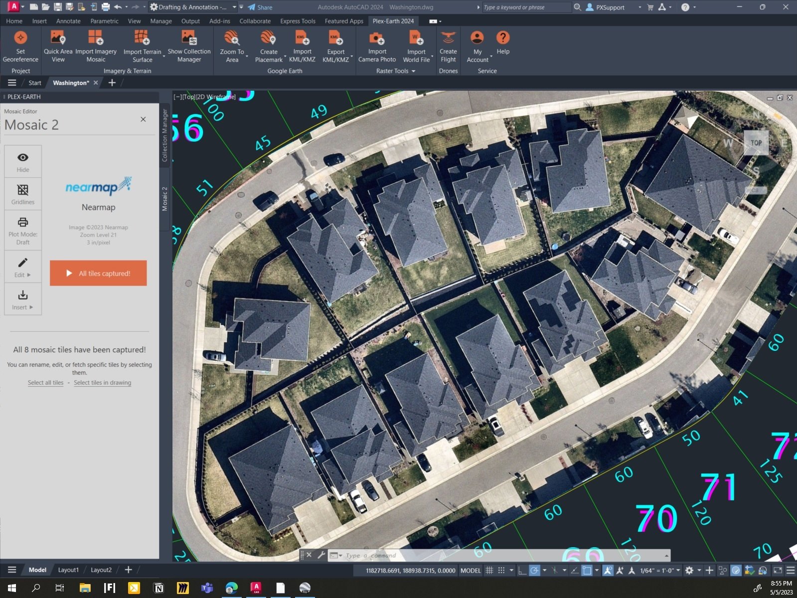
Let’s look at a great example, Nearmap:


Nearmap is one of our most popular premium providers for the 3 countries they cover, which are the United States, Australia and New Zealand.

Nearmap offers top-notch updated aerial imagery, down to an impressive resolution as fine as 3” – 7cm per pixel, and yes, automagically georeferenced, scaled and aligned for you, inside AutoCAD! This automatic aspect of Plex-Earth saves you a LOT of time or re-tries, and time is money!

You can do this either by using your own API key (if you already have a subscription with Nearmap) or by purchasing data directly from Plexscape and benefit from Plex-Earth’s acclaimed user interface. Using Plex-Earth optimizes both image clarity and the way you use your data, specifically for civil engineering and architectural use, without you needing to keep zooming or panning around.

Want to learn more about how Plex-Earth can geo-visualize your next, or even your current project, because it’s so easy to use? Then contact us and we’ll be glad to show you the process and answer any and all of your questions.

Or you can just start designing with Plex-Earth right now, because you can download your fully-functional free trial.

Plexscape’s response to COVID-19 pandemic: Free Plex.Earth licences for remote working

Plexscape’s response to COVID-19 pandemic: Free Plex.Earth licences for remote working

In response to COVID-19 pandemic, Plexscape, developers of Plex.Earth®, one of the most popular AutoCAD tools for the acceleration of architectural, engineering and construction (AEC) projects, is doubling its customers’ licenses at no extra cost, for the next 3 months.
This initiative aims to help thousands of Plex.Earth users in more than 120 countries worldwide to have a smooth transition to the new remote-work conditions by installing the software on their home computers or laptops, free of charge.

We're here for you: Free Plex.Earth activations during COVID-19 pandemic

We're here for you: Free Plex.Earth activations during COVID-19 pandemic

Seeing how bad the COVID-19 situation seemed to be we arranged for our own staff to work remotely, but we wondered, could we help and encourage YOU, our Plex.Earth users, to do the same? Consequently, we decided to double your Plex.Earth licensed machines, without any extra charge, for the next 3 months.

This Christmas, we lend a hand to those in need

You get more by giving, don't you think? We firmly believe so.

That's why, this Christmas we decided to support the work of Doctors Without Borders and their mission to provide lifesaving medical care to the people who need it most, in more than 70 countries worldwide.

From all of us, we wish you laughter and love as you celebrate your holidays with family and friends, and we look forward to a peaceful and prosperous 2020!

medicins sans frontieres_plexscape .png
 

Plex.Earth Timeviews™ empowers AEC professionals with the latest satellite imagery within AutoCAD

Plex.Earth Timeviews™ empowers AEC professionals with the latest satellite imagery within AutoCAD

Plexscape, developers of Plex.Earth®, one of the most popular tools for AutoCAD for the acceleration of architectural, engineering and construction (AEC) projects, launched Timeviews™, a unique service in the global AEC market, which makes the most up-to-date satellite imagery affordable and easily accessible within AutoCAD.

Introducing Plex.Earth Timeviews™: View the most up-to-date satellite imagery in AutoCAD

How many times did you wish you could have the current view of your project area? Outdated imagery can lead to costly design mistakes. Not anymore.

We have launched Plex.Earth Timeviews™, our new premium service, which brings Bird.i's up-to-date satellite imagery from DigitalGlobe, Airbus and Planet into your designs. Now you can get the most current view of your project area for any place in the world (you can read more here).

To guide you through Timeviews™, we have prepared a tutorial to show you how easy is to view the newest satellite imagery into your AutoCAD designs, for any project in the world.

Do you want to get free and unlimited access to Timeviews™ until the 31st of August?

We have an exclusive offer currently running for our amazing customers and anyone who wants to grab a new Plex.Earth subscription now!

Just make sure you download the newest version of Plex.Earth and follow the in-app instructions.

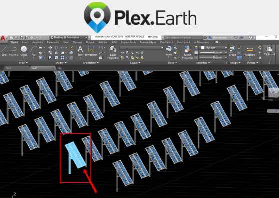
3 tips to optimally export your 3D AutoCAD designs to Google Earth (Solar farm example)

Design should be a productive experience, not a laborious process don’t you think? We constantly improve Plex.Earth to increase your workflow efficiency and enable any engineer focus on what matters most: his/her design.

Therefore, we have put together a detailed tutorial with three clever tips to show you how you can export your 3D AutoCAD designs into Google Earth faster, better and more efficiently.

Take a look here and don’t forget to start your free trial today. The latest version of Plex.Earth is out with new features like this one and important improvements!

The story behind Plex.Earth: Taking the guesswork out of civil design

The story behind Plex.Earth: Taking the guesswork out of civil design

You have just won your next project and can't wait to create a model for your design. You have been in that position, right? Then, you know it: the whole process can be a cumbersome, time-consuming and prone to errors experience.

In 2009, Lambros Kaliakatsos, Plexscape founder & CEO, being a CAD manager back then, got a bitter taste of the difficulties designing without having the complete real-world view of his sites, anytime he needed it.

Having experienced the high cost of rework on projects he was responsible for, he decided to do something about it.

So, in case you wonder, here’s our story, as published in the TwinGEO magazine by the popular blog Geofumadas!

Copy KML/KMZ objects from Google Earth to AutoCAD with Plex.Earth

We have introduced a powerful new feature in the latest version of Plex.Earth 4, which allows you to import objects from Google Earth into AutoCAD with a simple copy and paste operation.

You can even import KMZ elements that are loaded dynamically into Google Earth!

Interested to find more? Read our tutorial here.


Free webinar: 3D vehicle simulations in Google Earth with Plex.Earth and AutoTURN Pro

Looking to publish your 3D vehicle simulations in Google Earth?

We’re hosting a free webinar with our trusted partners, Transoft Solutions, to show you how you can do this easily and quickly, with Plex.Earth and AutoTURN Pro.

Join this webinar to learn how to import the most up-to-date satellite imagery, create swept path analyses and display the end result in Google Earth.

The benefits are numerous:

► You can share breathtaking presentations with anyone you want.
► Take instant feedback whenever you need it to meet your project deadlines.
► Impress your clients and land new ones.

Plex.Earth and AutoTURN Pro live webinar
Date: Thursday, June 13, 2019
Time: 10:00 AM PT | 12:00 PM CT | 18:00 PM CET
Hosts: Nicolas Paraskevopoulos, Customer Support Specialist at Plexscape
Majo Varghese, Sales Consultant at Transoft Solutions


How to create live tours in Google Earth, for your AutoCAD design, with Plex.Earth

How to create live tours in Google Earth, for your AutoCAD design, with Plex.Earth

Showcasing your AutoCAD design to Google Earth and sharing it with others can be vital for your project: Winning that customer, taking instant feedback, convincing local authorities/communities and shareholders for your design.

What about not just exporting your design but also creating realistic videos and immersive live tours in Google Earth?

We have created a tutorial to show you how you can easily do that with Plex.Earth to engage anyone you want from the early stages of your design, reducing subsequent and unproductive iterations that cost you time and money.

How to create terrain contours with Plex.Earth

contours plexearth .jpg

With Plex.Earth 4, you can visualize terrain morphology with elevation contours and import thousands of terrain elevation points into AutoCAD, automatically and incredibly quickly.

We have created a detailed tutorial to guide you through the process of creating contours easily with Plex.Earth 4.

For a detailed guide on how to import terrain, check our post on our support section.

You are one step away from focusing on what matters most: your design. Start your free trial today and watch this space for more!

Lineweight options when exporting AutoCAD drawings to Google Earth

Do you want to assign lineweights to the polylines that you export to Google Earth, as KML/KMZ files?

Normally, when you publish elements, they attach to Google Earth in only one size by default (1 Google Earth unit) and they do not change when zooming in or out.

Plex.Earth 4 allows you to define lineweights to your drawings choosing from constant width, multiplier and physical scale.

Read our detailed tutorial for more and start your free trial today!


How to create imagery and terrain corridors with Plex.Earth 4 (roadwork/railroad projects)

final2.jpg

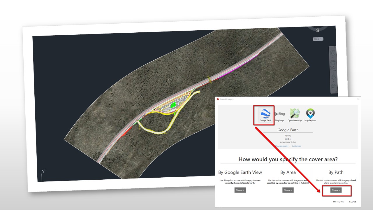
Looking to import imagery/terrain along a corridor into AutoCAD for your roadwork or railroad project?

We have prepared a tutorial to show you how to do this, with Plex.Earth 4, easily and quickly: By choosing to import imagery using the “By Path” option, you can decrease the import time significantly and boost your productivity.

Check it out and watch this space for more tutorials and helping materials!


How to connect to the Hellenic Cadastre with Plex.Earth 4

PHOTO2.jpg

Plex.Earth enables thousands of engineers worldwide to have the complete 3D geographical view of their project sites within minutes, through Google Earth, Bing Maps, OpenstreetMap or any other WMS provider.

For those based in Greece, we have prepared a tutorial to show you how to connect to the Hellenic Cadastre with Plex.Earth 4, easily and quickly.

The Hellenic Cadastre records the legal, technical and other additional details about real estate properties and the rights on them, meaning that every person or legal entity that owns a real property or a registrable right on real property is obliged to submit a declaration to the service.

Due to the non-proper spatial representation of real estates mostly in rural areas, the submission of a dependent topographic diagram is required.

Thanks to Plex.Earth’s integration with the Web Map Service (WMS) of the Hellenic Cadastre, every land surveyor and civil engineer can have the real-world representation of a land property.

Also, with Plex.Earth’s 4 powerful mosaic tools, you can import hundreds of high-resolution images into AutoCAD from the service and merge them into one in few minutes, covering even the largest areas.

You can read our tutorial here and try Plex.Earth 4 for free today!

Sparking young minds with robotics: Two Greek students share their life-changing stories

Sparking young minds with robotics: Two Greek students share their life-changing stories

What about making robotics as cool for young people as sports are today;

Just a few months ago, two Greek university students, Georgia Kouvoutsaki and Vasilis Kokkinos, 23 and 21 years old, were selected to be on the panel of judges for the World Robotics Olympiad in Thailand.

Realizing how passionate they both are, we were more than glad to support them in their mission. Here's their inspiring stories that hopefully will encourage other young people and especially school students, to explore the magic world of robotics and science!


How to 3D print terrain created with Plex.Earth 4 (Civil 3D users)

PHOTO 3D PRINT TERRAIN.jpg

Most 3D printing professionals, like Aristeidis Loukrizis (read his story here) have to visualize the surrounding environment and represent the terrain morphology of a project area to reproduce it in their final 3D printed models - a process that is time-consuming and prone to errors.

However, they can overcome these difficulties and create the desired 3D printed models with Plex.Earth, easily and quickly.

We’ve prepared a detailed tutorial to guide you step by step on how to create a 3D solid object from your imported terrain with Plex.Earth, before exporting it as an .stl file which is proper for 3D printing.

Read it through and stay tuned for more technical resources and tutorials.

You can also unlock Plex.Earth’s 4 powerful capabilities by starting your free trial today!

Plex.Earth is featured on DigitalGlobe's official blog

Data is the new oil, don’t you think? We firmly believe so!

Our new partnership with Bird.i is based on our shared vision to bring the value of the most up-to-date satellite imagery to businesses of any size for better -informed decision making (you can read our joint press release and visit our page for more information).

Corentin Guillo, Bird.i CEO, has written a great guest post on DigitalGlobe company blog about our partnership, explaining the real value it brings to the Architecture, Engineering and Construction (AEC) industry.

DigitalGlobe is a leading provider of high-resolution Earth imagery, data and analysis, owning and operating an agile and sophisticated constellation of
high--resolution commercial Earth imaging satellites.

Read the guest post here and watch this space for more news and updates regarding this powerful partnership.

JPG Quality: Image Clarity vs File Size

3.jpg

Is your AutoCAD drawing file size too large because it contains big mosaics?

Nikos Chanakoulas from our technical support team explains in a detailed tutorial, how you can set the JPG quality to the desired level to decrease the file size.

The difference can be very subtle in imagery clarity and you can work with smaller files, taking not much space on your hard drive!

Read more here.

Plexscape partners with Bird.i to offer up-to-date satellite imagery integration within CAD platforms

Plexscape partners with Bird.i to offer up-to-date satellite imagery integration within CAD platforms

Plexscape, developers of Plex.Earth®, one of the most popular tools for AutoCAD for the acceleration of architectural, engineering and construction (AEC) projects, and Bird.i, a start-up that combines the latest satellite imagery and artificial intelligence technology to provide valuable business insights, are on a mission to change the way engineering projects are being designed by opening up access to high-quality geospatial data to the global AEC market.