PRESS RELEASES

Formidable! Plex-Earth Meets Forma and more, at AU23…

Autodesk University 2023 wasn't just the biggest event in the AEC world – it was a groundbreaking showcase of the AEC future - and Plex-Earth is right at the heart of it!

But first, a hat-tip to Nick…

Nick’s Class was a Sold-Out Success Story – Twice!

Nick Chanakoulas, our Head of Customer Success, started AU23 with his own impressive success, leading a live class that was a total hit by selling out before the conference even started!

The demand was so high that Autodesk set up a rare second session, which, unsurprisingly, also sold out!

Nick’s classes have a well-deserved reputation from previous AUs, so we were hopeful for it to be popular again this year, but we weren’t expecting a packed, 150+ crowd, with some willing to stand at the back without seats!

And check out that ceiling!

This year he was introducing the Geospatially-informed Design framework, created right here by the Plex-Earth team (more about that in a minute…)

That he packed every chair, twice, is a testament to the growing interest in integrating real-world data into project planning, a field where Plex-Earth has always excelled, but above all it’s a tribute to Nick himself. Well done Nick!

The Future of Autodesk’s Ecosystem – Forma

Autodesk's CEO, Andrew Anagnost, kicked off the event by spotlighting Autodesk Forma, the latest addition to the Autodesk family, and arguably the new heart of it.

Forma, a cloud-based AI and generative design tool, is set to revolutionize the future of AEC, and those are not idle words!

It truly is a futuristic platform, based on Spacemaker, which Autodesk acquired in 2020 for $240 million. Forma stands alongside Fusion (for manufacturing) and Flow (for entertainment), creating a triad that represents Autodesk's future vision.

It's primarily designed for use at the early - and thus critical - stages of AEC construction, and complements, not replaces, tools like AutoCAD and Revit.

As Nicolas Mangon, vice president of AEC strategy at Autodesk said in an interview with ENR regarding where Forma will sit in the Autodesk line-up:

"This is not a replacement of Revit, it's a different way of working. Some will still use AutoCAD, others will use Revit, some will use … Forma. Forma is designed to be used at the planning phase of building."

Seeing the bigger picture, then zooming in on the details of early planning is where Plex-Earth has always excelled. Now we're bringing our geospatial expertise right into the heart of this exciting new platform!

Yes, drumroll please…

Plex-Earth is now one of the first 3rd-party extensions ever accepted for Autodesk Forma!

Captured is the moment we were informed Plex-Earth is officially published as a Forma extension!

Pictured above are Andrew Kinaci (center left) and Håkon Dissen (front left) from the Forma team, and from Plex-Earth our CEO Lambros Kaliakatsos (front right) with COO Andreas Bavas doing the antenna fingers behind him!

If you squint, behind Håkon’s shoulder you can also spot Krzysztof (Chris) Jedrzejewski, from Forma. Along with Håkon he helped us a lot with fast-tracking this project – thank you guys!

This integration of Plex-Earth with Forma means more than just convenience; it’s the experience, a seamless, data-rich platform connecting you and your project with the real world, and with everyone involved.

It will enhance your design before the first draft is even created!

When Autodesk Forma meets Plex-Earth it means:

  • Enhanced Efficiency: No more toggling between different applications. Access our data and everything else you need within the Forma ecosystem

  • Data-Driven Decisions: With our premium, updated and historical imagery and data, you make smarter, more informed choices in the early and critical stages of the design process

  • Collaboration Made Easy: Share and collaborate with your own and other teams seamlessly, with all your data and imagery in one place, online!

We’ll be revealing more technical information about the Plex-Earth Forma extension as we finalize documentation, and YES, a free trial is already available!

Our Busy-Bee Booth

Our booth at AU23 was a hive of activity, buzzing with interactions and connections, including some exciting conversations with other big movers in AEC, such as ESRI coming to visit us!

As usual though, we were thrilled to meet you, our end-users face-to-face, exchanging ideas, and sharing experiences!

This direct engagement with you is always the highlight of our presence at Autodesk University, and a key reason why we’re willing to regularly be premium Silver Sponsors of this event.

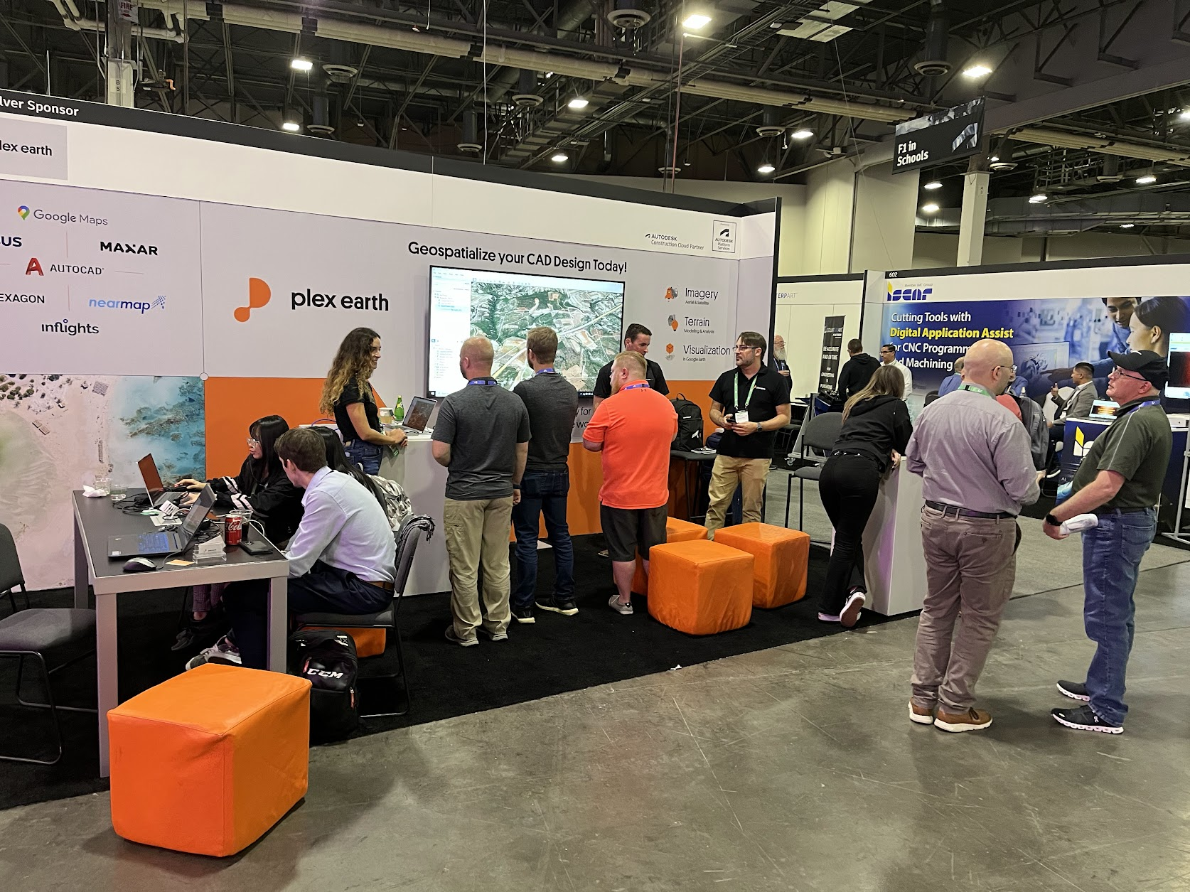
Pictured is actually one of the quiet moments, when we had time to breath and take a snap!

Geospatially-informed Design (GiD) Handbook – The Smash Hit!

The release of the Geospatially-informed Design framework, and its accompanying handbook, was a runaway success!

We brought 99 printed copies of the handbook, and they were snapped up immediately, with attendees still clamoring for more during Nick’s classes!

The handbook’s popularity just further confirms the demand for data-driven insights in the AEC industry!

YES, we're planning a reprint soon, making it available for purchase – a perfect Christmas gift for senior engineers or a strategic addition to your Zoom background!

In conclusion, AU23 was not just a conference; it was a pivot to a new era in AEC, and a very welcome return to the human contact that makes everything so special.

As Plex-Earth integrates with Forma, we're also a (very proud!) part of this exciting transformation, bringing you enhanced efficiency, data-driven decisions and seamless collaboration.

We're not just riding the wave of the future; we're shaping it, together with Autodesk and you, our incredible community. Stay tuned for more updates, and as always, happy designing!

Quick links:

Geospatially-informed Design (GiD) Handbook released for AU23!

Popular geospatial plugin maker Plex-Earth is releasing a new handbook, laying out the 3 principles of Geospatially-informed Design (while also promising a BIG surprise for AU23 at Las Vegas, of which they are again a Silver Sponsor)…

Weighing in over 170 pages, the handbook is a useful reference and a guide, but at its core it is a statement of principles.

The primary principle is the fact that better inputs allow for better outputs, and here the focus is on how a deeper, more comprehensive understanding of the project area allows engineers to create better designs, whilst also avoiding errors.

The 3 principles are:

The Principle of Data Accessibility

“This principle emphasizes the importance of ensuring that geospatial data necessary for informed design decisions is readily available to all relevant stakeholders throughout the AEC project lifecycle.”

The Principle of Field-Design Integration

“This principle emphasizes the importance of establishing mechanisms and practices that enable seamless and timely collaboration between design teams and field personnel throughout the various phases of an AEC project”

The Principle of Sustainable Design Integration

“This principle promotes the seamless integration of geospatial data and design concepts in AEC projects, emphasizing the use of visualization to communicate and illustrate sustainable design strategies. Visualization enhances stakeholder understanding and supports informed decision-making, facilitating the creation of environmentally responsible and visually compelling projects.”

Naturally the AutoCAD plugin Plex-Earth helps greatly with most of the above, as it brings AutoCAD users premium quality satellite and aerial imagery, detailed terrain data and integration with other data services.

Dropped hints and the familiar but wider-than-usual grin of Plexscape CEO Lambros Kaliakatsos suggest a new version, or even an entirely new product, may soon fill the remaining gaps.

He said “We envisioned and developed the Geospatially-informed Design (GiD) framework, with Plex-Earth being the first software built on these principles, tailored to meet the specific needs of designers.”

 “We envisioned and developed the Geospatially-informed Design (GiD) framework, with Plex-Earth being the first software built on these principles” CEO Lambros Kaliakatsos

The handbook will be released publicly at Autodesk University 2023 (AU23).

Pressed for details about any other announcements for the world’s largest annual AEC conference, he simply replied that “Something big is in alpha status, so watch this space!”

Nick Chanakoulas, head of Customer Success, will once again hold a live training session at AU23. This has proven incredibly popular, to the point this year’s course is already sold out and Autodesk have approved the creation of a second one. This puts the course in elite company, as for the entire conference only 7 such courses have been granted this honor. Update: The 2nd course is already fully booked.

Autodesk University 2023 will be held at The Venetian Resort in Las Vegas, Nevada, from Monday, November 13th, to Wednesday, November 15th.

Plexscape has booth number 606, which is right by the doorway for food so if you’re attending in person you’re sure to spot them!

Plex-Earth-Inflights integration; get cm-scale drone data in your AutoCAD projects!

Plexscape, which brings satellite imagery and terrain data into AutoCAD, is partnering with drone surveying company Inflights, giving civil engineers both the bigger-picture for preliminary design and now also ultra-detailed drone surveying data for precision construction.

Plexscape's flagship product is Plex-Earth, which is primarily used to scout out suitable areas and for fast conceptional planning via georeferenced satellite and aerial imagery with terrain data. As such it's a firm favorite for instantly seeing the bigger picture for ideas and inspiration, picking the best angles and avoiding errors.

Inflights offers a variety of drone surveying solutions offering centimeter-scale up-close detail of existing structures and landscapes, making it ideal for the later stages of projects.

PIONEERING PARTNERSHIP

Both companies can rightfully claim to be pioneers within their respective fields. Plexscape has a string of 'firsts', such as the first SaaS plug-in and the first to bring orthorectified satellite imagery into AutoCAD, while Inflights is the world's first platform to obtain, process and professionally analyze drone data globally.

Another similarity of the two companies is that both are driven by expert CEO founders. Inflights CEO Hugo De Blauwe is an aerospace engineer and private pilot by training, while founding CEO of Plexscape is Lambros Kaliakatsos, a software developer and experienced civil engineer of larger-scale projects.

Inflights CEO Hugo De Blauwe visits Plex-Earth HQ

Joining forces; Plexscape CEO Lambros Kaliakatsos and Inflights CEO Hugo De Blauwe at Plexscape headquarters, Athens, 5th May 2022

Both of them seek a more sustainable world where engineers can see and design for the real world, without the time, risk and expense of traveling.

GOING BEYOND GOOGLE

Plexscape's flagship product Plex-Earth and its free sibling Plex-Earth Lite can both connect AutoCAD with Google Earth. The paid version also offers easy and affordable access to satellite and aerial imagery from premium providers, such as Airbus, Maxar, Nearmap and Hexagon, along with terrain data from Google and Cesium.

Adding a drone image and data provider was the obvious next step for Plexscape, but they have held back until today, waiting for a mature and reliable solution. They now see Inflights as that winning solution, as Inflights has solved the scaling problem of covering a big world with many drone pilots each covering a small region. They have done this by building a global drone pilot community, each of them being the business owners of their local entity. .

The knowledge of local pilots carries many advantages, ranging from recognizing the best weather windows, to knowing the local laws and regulations for flying drones over various types of locality and structure. The biggest advantage might even be the most obvious one, being close to the location drastically reduces the travel time and cost. Inflights’ credo summarizes this well: “We want our pilots to fly rather than drive” Bringing such professionals into the fold of a large, reputable company creates a potential win-win for both pilots and their engineering clients.

The new partnership with Plexscape, who have been Autodesk Authorized Developers since 2010, will help realize that potential because engineer clients are something Plexscape already has plenty of. Their products have long been perennial favorites on both the AutoCAD and BricsCAD app stores.

Visit https://plexearth.com and https://inflights.com for more information on their products and services.

ABOUT – Inflights is a platform to obtain, process and analyze drone data. Inflights is aiming to make it more cost effective to get highly-accurate 3D measurements anywhere in the world. This is done via a global network of drone pilots who perform flights and upload the resulting data onto their  platform, allowing consistent results with expert processing and analysis.

Plexscape is a software company committed to bridging the gap between design and the real world. Plex-Earth, their flagship product, was the first cloud-based software ever created in the CAD market, and is today one of the most popular tools in the Autodesk App Store, being used by thousands of engineers in over 120 countries worldwide on a daily basis.

Plex-Earth 5D: Plexscape launches new platform during Autodesk University 2021 - Taking the guesswork out of civil design

Plex-Earth 5D: Plexscape launches new platform during Autodesk University 2021 - Taking the guesswork out of civil design

Plexscape, developers of Plex-Earth, a full-blown popular platform for AutoCAD that brings the world’s largest aerial and satellite imagery providers under a single umbrella, participates again in this year’s Autodesk University as a premier sponsor.

Plexscape will be officially launching Plex-Earth 5D, its latest most powerful version during Autodesk University, as it is the year’s biggest event for the Architecture, Engineering and Construction (AEC) industry.

Plex-Earth expands to BricsCAD to empower AEC professionals with premium satellite and aerial imagery 

Plex-Earth expands to BricsCAD to empower AEC professionals with premium satellite and aerial imagery 

Plex-Earth, a full-blown popular platform for AutoCAD that brings the world’s largest aerial and satellite imagery providers under a single umbrella, now expands its offering to BricsCAD, to inform smart engineering with recent, historical, high-quality imagery and terrain data.

Plexscape and Airbus join forces to offer the best satellite imagery to the AEC industry

Plexscape and Airbus join forces to offer the best satellite imagery to the AEC industry

Following a partnership between Plexscape and Airbus, engineers using AutoCAD can now have easy and fast access to OneAtlas, the Airbus’ geospatial digital platform delivering the freshest satellite imagery, through the new version of Plex-Earth.

By getting access to recent imagery, engineers get a complete understanding of their project sites' conditions from the very beginning of their design workflow, speeding up processes and avoiding the high cost of rework by reducing errors.

New Satellite & Aerial Imagery Platform launched by Plexscape during Autodesk University Conference - Going beyond Google Earth

A dramatic update of popular AutoCAD imagery plugin Plex-Earth launches at this year’s online-only Autodesk University, switching from just Google Earth to images from top imagery providers Airbus, Maxar, Nearmap And Hexagon.

Plexscape’s response to COVID-19 pandemic: Free Plex.Earth licences for remote working

Plexscape’s response to COVID-19 pandemic: Free Plex.Earth licences for remote working

In response to COVID-19 pandemic, Plexscape, developers of Plex.Earth®, one of the most popular AutoCAD tools for the acceleration of architectural, engineering and construction (AEC) projects, is doubling its customers’ licenses at no extra cost, for the next 3 months.
This initiative aims to help thousands of Plex.Earth users in more than 120 countries worldwide to have a smooth transition to the new remote-work conditions by installing the software on their home computers or laptops, free of charge.

Plex.Earth Timeviews™ empowers AEC professionals with the latest satellite imagery within AutoCAD

Plex.Earth Timeviews™ empowers AEC professionals with the latest satellite imagery within AutoCAD

Plexscape, developers of Plex.Earth®, one of the most popular tools for AutoCAD for the acceleration of architectural, engineering and construction (AEC) projects, launched Timeviews™, a unique service in the global AEC market, which makes the most up-to-date satellite imagery affordable and easily accessible within AutoCAD.

Plexscape partners with Bird.i to offer up-to-date satellite imagery integration within CAD platforms

Plexscape partners with Bird.i to offer up-to-date satellite imagery integration within CAD platforms

Plexscape, developers of Plex.Earth®, one of the most popular tools for AutoCAD for the acceleration of architectural, engineering and construction (AEC) projects, and Bird.i, a start-up that combines the latest satellite imagery and artificial intelligence technology to provide valuable business insights, are on a mission to change the way engineering projects are being designed by opening up access to high-quality geospatial data to the global AEC market.

Plex.Earth and AutoTURN PRO free webinar: How to create the most realistic 3D vehicle simulations in Google Earth

Plexscape has partnered with Transoft Solutions allowing engineers and designers to create and share impressive presentations of their swept path analysis into Google Earth.

Following the integration of their popular software, Plex.Earth and AutoTURN PRO alike, the two companies announce their first free webinar which will take place on Thursday 13th of December at 11:00 AM CET (12:00 GMT+2 or EET).

Those who are interested can register here.

This in-depth training run by in-house specialists of both software will show engineers and designers how to import high-quality satellite imagery, create swept path analysis and display the end result in the Google Earth environment.

The attendants will have the opportunity to experience first-hand the value of bringing together Plex.Earth with AutoTURN technology, as shown in this video.

According to “Make it, or break it - Global Construction Survey 2017” by KPMG, companies still struggle to deliver projects on time and within budget.

However, by publishing their 3D vehicle content in Google Earth, engineers now have a powerful tool in their hands: they can create and share breathtaking presentations with their customers or colleagues and take instant feedback, whenever they need it. Therefore, they can reduce revisions and meet their project’s deadlines and budget goals.

All registrants will receive a full recording of the presentation, so they can sign up even if they’re not sure they can attend.

Plex.Earth and AutoTURN PRO webinar
DATE: Thursday, December 13, 2018
TIME: 11:00 CET (12:00 GMT+2 or EET).
HOSTS: David Homola, Product Manager at Transoft Solutions EMEA,
Nicolas Paraskevopoulos, Customer Support Specialist-Civil Engineer at Plexscape

About Plexscape

Plexscape is a software company committed to changing the way engineers work on Architectural, Engineering, and Construction (AEC) projects, by developing innovative solutions that bridge the gap between design and the real world.

Plex.Earth, our flagship product, is the first cloud-based software ever created in the CAD market and one of the most popular tools in the Autodesk App Store.

Our solution, originally released in 2009, is being used by more than 15,000 engineers in over 120 countries worldwide, enabling them to have the complete 3D geographical view of their real-world project sites within minutes, through Google Earth and other satellite data providers. For more information on Plex.Earth's benefits, visit www.plexearth.com.

About Transoft Solutions

Transoft Solutions develops innovative and highly specialized software for aviation, civil infrastructure, and transportation professionals. Since 1991, Transoft has remained focused on safety-oriented solutions that enable transportation professionals to design with the utmost confidence. Our portfolio of planning, simulation, modeling, and design solutions, are used in over 130 countries serving more than 50,000 customers across local and federal agencies, consulting firms, airport authorities, and ports. We take pride in providing best-in-class customer support from our headquarters in Canada, and through offices in Sweden, the United Kingdom, Netherlands, Australia, Germany, India, Belgium, and China.

For more information on Transoft’s range of trusted and field-tested engineering software, visit www.transoftsolutions.com/emea.


Transoft Solutions and Plexscape partnership offers the most realistic 3D vehicle representation on Google Earth

Transoft Solutions Inc., a global leader in transportation engineering design and analysis software, has partnered with Plexscape, developers of Plex.Earth®, one of the most popular tools for AutoCAD for the acceleration of architectural, engineering and construction (AEC) projects. Central to the partnership was integrating AutoTURN® technology with Plex.Earth to allow engineers and designers to demonstrate vehicle swept path analyses directly into Google Earth enabling them to create and share engaging presentations and reduce revisions and overall cost.

“Civil engineering is about making the world a better place and here at Plexscape we are committed to help engineers by always giving them the most accurate real-world view of their project sites”, said Mr. Lambros Kaliakatsos, Founder & CEO of Plexscape. “For 9 years now, Plex.Earth, our flagship solution, enables them to have instant access to high-quality satellite imagery and terrain morphology data. We strongly believe that our partnership with Transoft Solutions, a company that has changed the way the future of transportation is being designed, will help AEC professionals make design decisions with more confidence and keep their projects on time and on budget".

This statement is fully aligned with Transoft’s mission to provide solutions that allow its customers to design with the utmost confidence.

“Plex Earth is a perfect addition to AutoTURN Pro. In our partnership with Plex.Earth we made sure that our massive 3D vehicle content is displayed well in Google Earth” says Alexander Brozek, Vice President & General Manager of Transoft Solutions EMEA. Engineers can easily demonstrate their performed swept path analysis for impressive and self-explaining presentations or running quick checks in the conceptional phase of a project. It was our pleasure to work with Plexscape on a project which makes the real capabilities of AutoTURN Pro to stand out."

About Transoft Solutions, Inc.

Transoft Solutions develops innovative and highly specialized software for aviation, civil infrastructure, and transportation professionals. Since 1991, Transoft has remained focused on safety-oriented solutions that enable transportation professionals to design with the utmost confidence. Our portfolio of planning, simulation, modeling, and design solutions, are used in over 130 countries serving more than 50,000 customers across local and federal agencies, consulting firms, airport authorities, and ports. We take pride in providing best-in-class customer support from our headquarters in Canada, and through offices in Sweden, the United Kingdom, Netherlands, Australia, Germany, India, Belgium, and China.

For more information on Transoft’s range of trusted and field-tested engineering software, visit www.transoftsolutions.com/emea.

About Plexscape MON. E.P.E.

Plexscape is a software company committed to changing the way engineers work on Architectural, Engineering and Construction (AEC) projects, by developing innovative solutions that bridge the gap between design and the real-world.

Plex.Earth, our flagship product, is the first cloud-based software ever created in the CAD market and one of the most popular tools in the Autodesk App Store.

Our solution, originally released in 2009, is being used by more than 15,000 engineers in over 120 countries worldwide, enabling them to have the complete 3D geographical view of their real-world project sites within minutes, through Google Earth and other satellite data providers.

For more information on Plex.Earth's benefits, visit https://plexearth.com/