
Vexcel imagery and terrain in Plex-Earth
The only Premium Provider with native 15 cm imagery across the entire U.S.
We are thrilled to welcome another leading Premium Provider to Plex-Earth. Vexcel operates one of the world’s largest aerial imagery programs, capturing highly detailed and accurate imagery across more than 45 countries using fixed-wing aircraft and UltraCam sensors. With consistent updates, oblique imagery, and commercial licensing, Vexcel gives professionals a reliable view of real-world site conditions for planning, design, and analysis.
Just like Nearmap, Hexagon, Airbus, and Vantor (formerly Maxar), Vexcel is now available through the same Plex-Earth workflows, with no provider-specific subscription required for either imagery or terrain.
Two ways to bring Vexcel data into your projects:
Imagery: It offers ultra-high-resolution imagery mosaics directly within AutoCAD, Civil 3D, and BricsCAD through the purchase of credits.
Terrain: In addition to imagery, Vexcel also offers terrain data, available on demand through the Plex-Earth Sales team. DTM and DSM data for your project area are delivered in GeoTIFF format and can be imported into Plex-Earth with just one click.
Vexcel Imagery Resolution
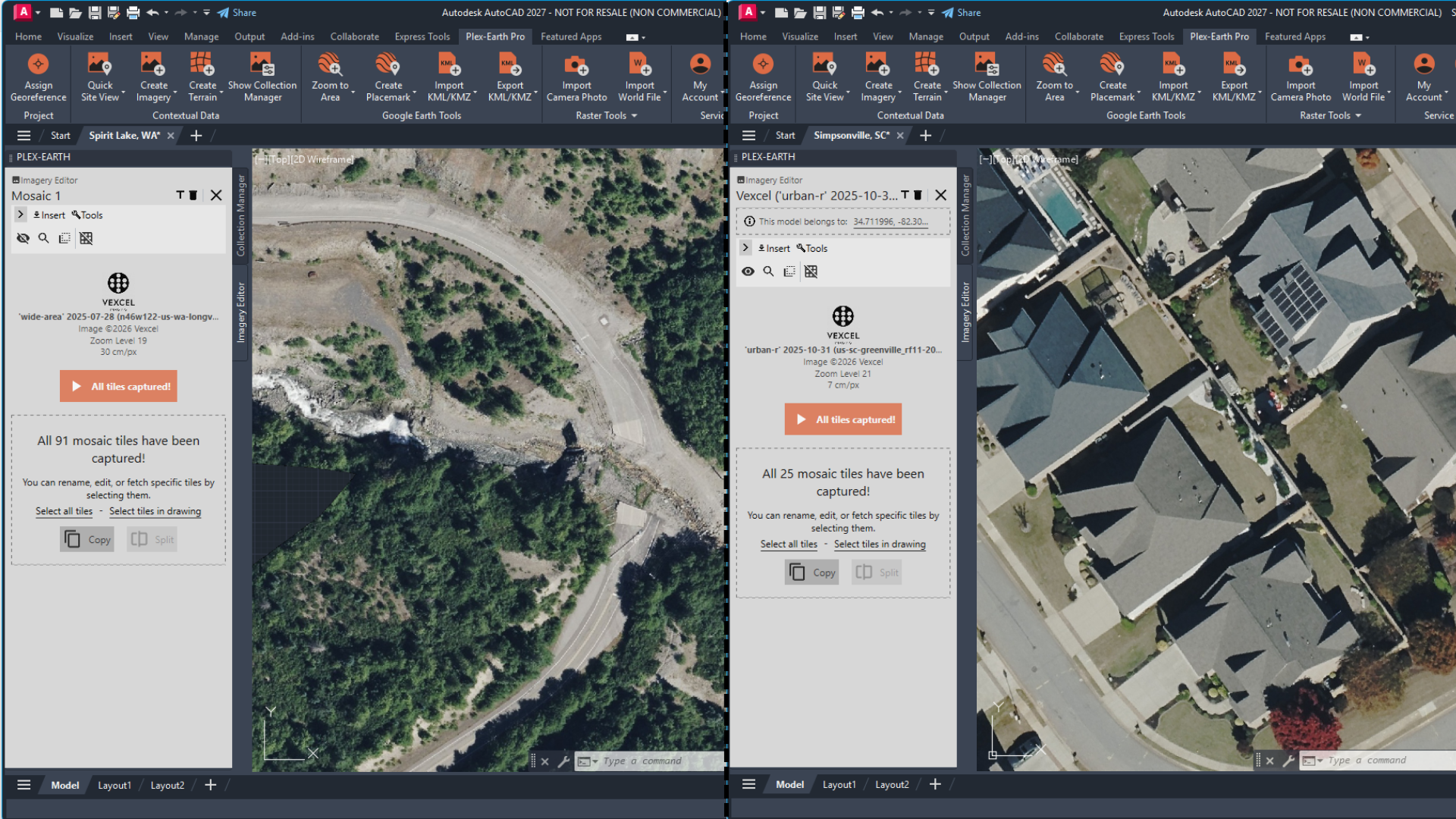
Plex-Earth images showing a rural & an urban area covered by Vexcel
Vexcel's Wide Area Program runs at 7.5 cm (about 3") ground sample distance in urban areas and 15 cm (about 6 in) in rural and wide-area coverage.
At 7.5 cm (about 3"), pavement edges, lane markings, curb returns, building footprints, manholes, fence lines, and ground-mounted equipment are all visible in enough detail to support feasibility decisions, layout reviews, and design coordination.
At 15 cm (about 6"), rural and corridor coverage still shows road edges, buildings, and major site features clearly enough to anchor design work over large areas.
For U.S.-based projects, an important update is coming in January 2027: Vexcel is doubling the resolution of its nationwide U.S. Wide Area Program from 15 cm to 7.5 cm across the contiguous 48 states. Vexcel also plans to extend this nationwide 7.5 cm approach across Europe, where it already maintains country-wide 15 cm coverage in more than 20 countries.
Data capture frequency & metadata
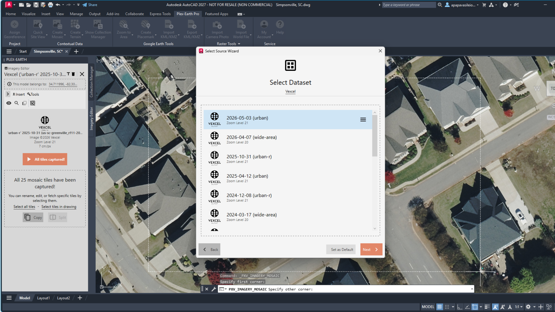
Vexcel datasets showing frequency in urban areas
Vexcel follows a scheduled aerial capture program, with update frequency varying by coverage type and location. Urban areas with 7.5 cm imagery are refreshed up to three times per year, while rural coverage is updated regularly, with rural towns typically captured more frequently (typically once per year) than remote areas (every few years).
All Vexcel imagery imported through Plex-Earth is orthorectified to correct terrain and sensor distortions, then georeferenced to the coordinate system of the drawing. Each image also includes its capture date in the metadata.
This information allows teams to verify the recency of the imagery used for existing-site analysis and maintain a clear record of the imagery source and capture date throughout the project. More info on metadata can be found here.
Vexcel Data Global Coverage
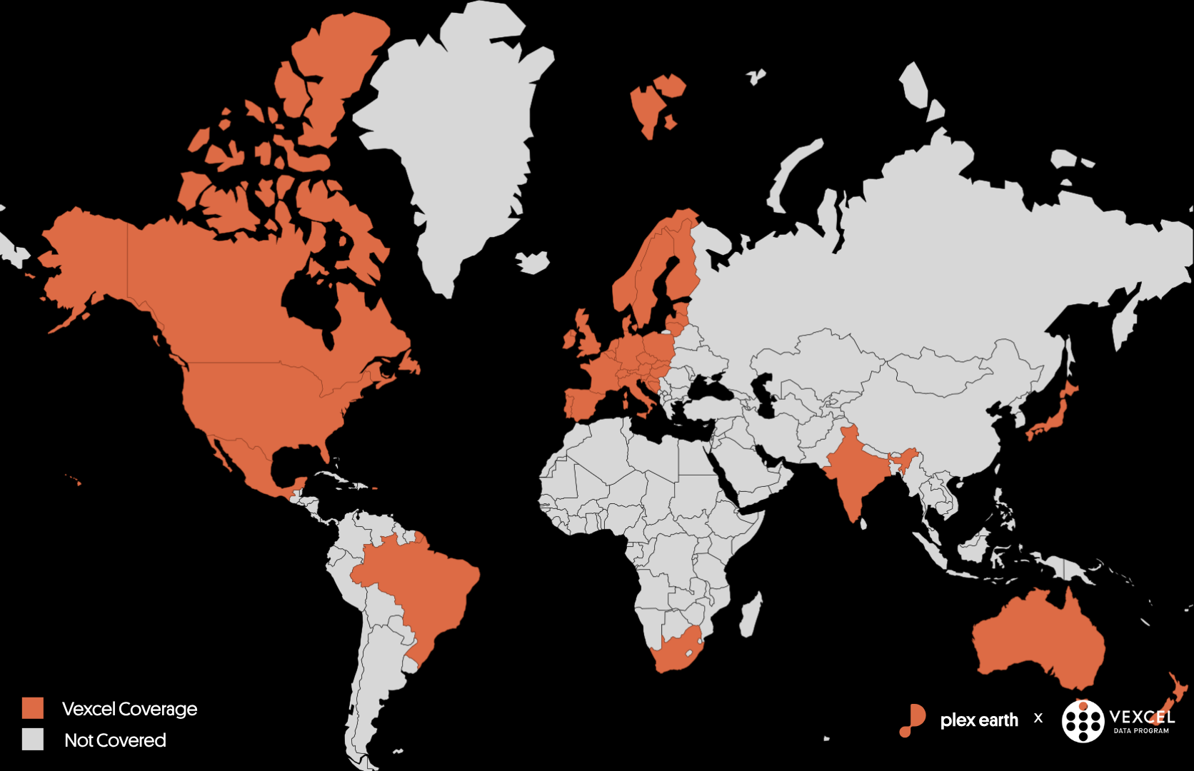
Vexcel operates in 45+ countries. Coverage varies by country — see details.
Vexcel’s aerial library covers wide-area and metropolitan imagery across 45+ countries, with full U.S. reach across all 50 states following Vexcel's recent addition of Alaska. Most of the published data sits at 7.5–15 cm (roughly 3–6 ") ground sample distance.
Confirmed countries in Vexcel's public collection program include:
North America: United States, Canada, Mexico
U.S.: all 50 states following Vexcel's recent addition of Alaska; 2026 refresh covers ~5.2 million km² (~95% of the U.S. population and 122M+ households); historical library going back to 2012.
Mexico: added in June 2026: ~50,000 km² across 40 metros, including Mexico City, Guadalajara, and Monterrey, all at 7.5 cm (3 ").
South America: Brazil
Europe: Austria, Belgium, Croatia, Czechia, Denmark, Estonia, Finland, France, Germany, Hungary, Ireland, Italy, Latvia, Lithuania, Luxembourg, Netherlands, Norway, Poland, Portugal, Slovakia, Slovenia, Spain, Switzerland, United Kingdom
~1 million km² planned for 2026, urban and rural. 20+ countries currently at 15 cm (6 ") countrywide.
Africa: South Africa
Asia: India, Japan
Oceania: Australia, New Zealand
Non-US, non-European regions: ~500,000 km² focused on major cities and metropolitan areas at 7.5 cm (3 ").
Where to find Vexcel in Plex-Earth
You can access Vexcel in Plex-Earth 2027 from two places:
In the Site Area:
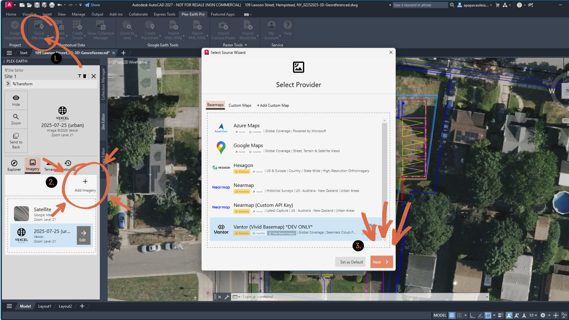
How to import Vexcel Imagery from Site Area in Plex-Earth
Open the Site Area in Plex-Earth.
Go to the Imagery tab.
Select Vexcel from the provider list.
In the Imagery Mosaic section of the ribbon:
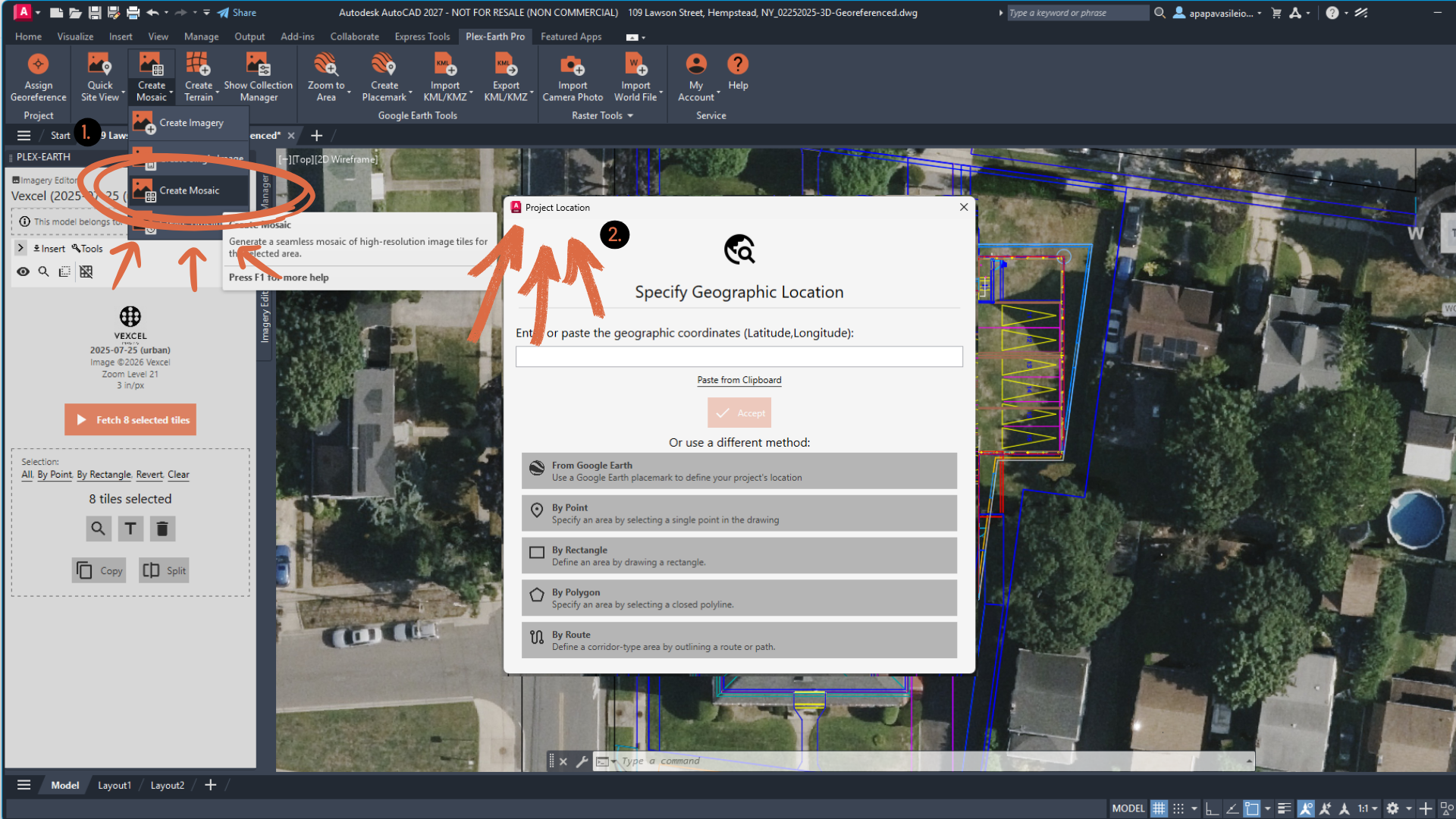
How to import Vexcel imagery in the Mosaic section of Plex-Earth
Go to the Imagery Mosaic section in the Plex-Earth ribbon.
Select Vexcel from the provider list.
Draw the area you want to import.
DTM and DSM data on demand
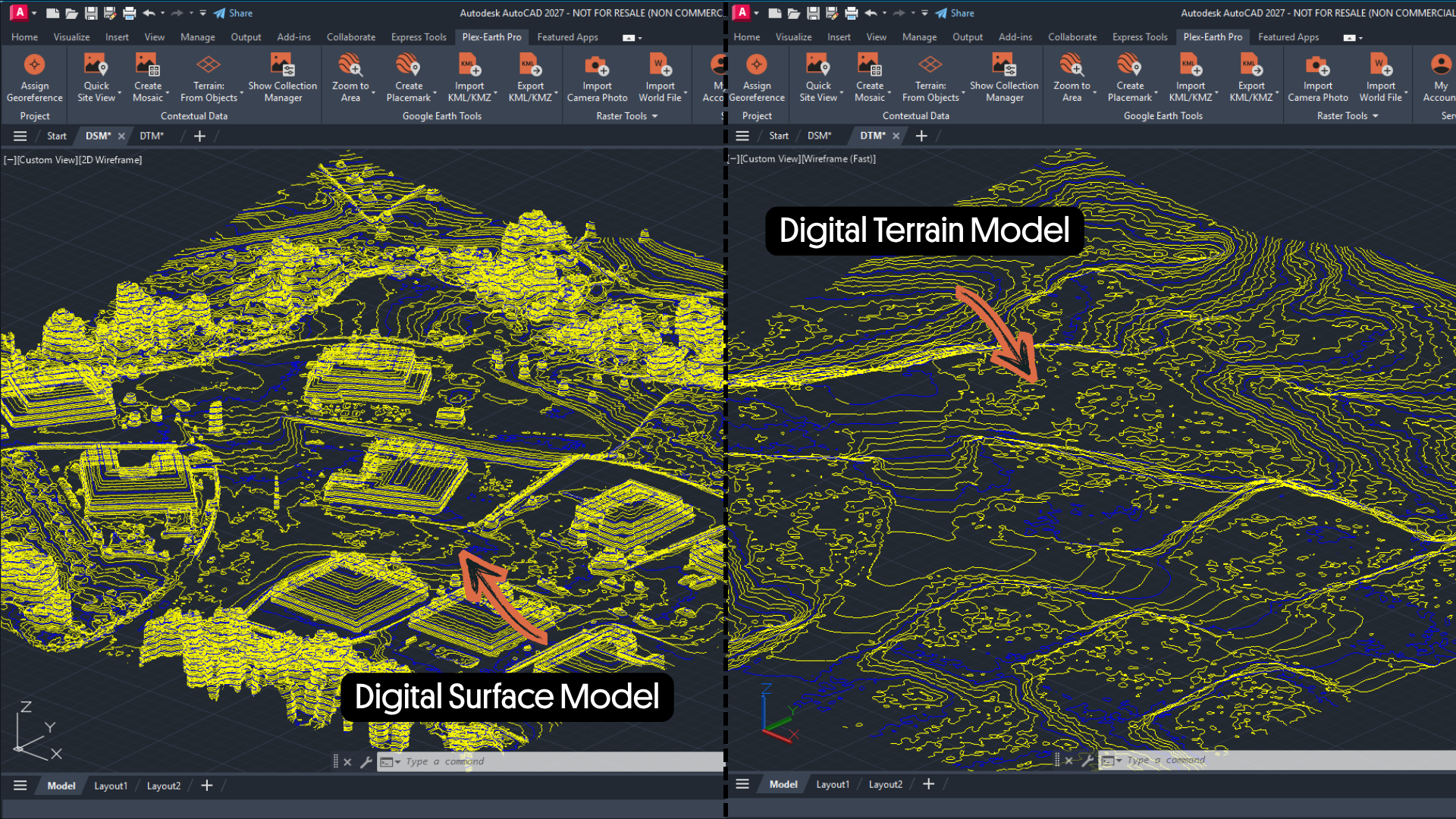
DTM & DSM from Vexcel Terrain data on demand
Alongside its imagery, Vexcel Digital Terrain Models (DTMs) and Digital Surface Models (DSMs) are now available through Plex-Earth. These elevation models are primarily derived from Vexcel’s aerial data through stereo processing and, in selected areas, LiDAR, and align with its ortho imagery, providing a consistent spatial reference by reducing discrepancies between the imagery and terrain used in a project.
Vexcel’s surface and elevation data provide an ideal level of detail between basemap and survey data, supporting grading, drainage and corridor design, as well as preliminary cut-and-fill estimates and slope analysis before external survey work is commissioned.
Similar to the imagery, the terrain data is dated and georeferenced, providing clear context for early design decisions. Terrain data is priced separately from imagery and is charged according to the size of the project area rather than the number of tiles.
Files are delivered in GeoTIFF format, ready to import into Plex-Earth using the Create Terrain from GeoTIFF command.
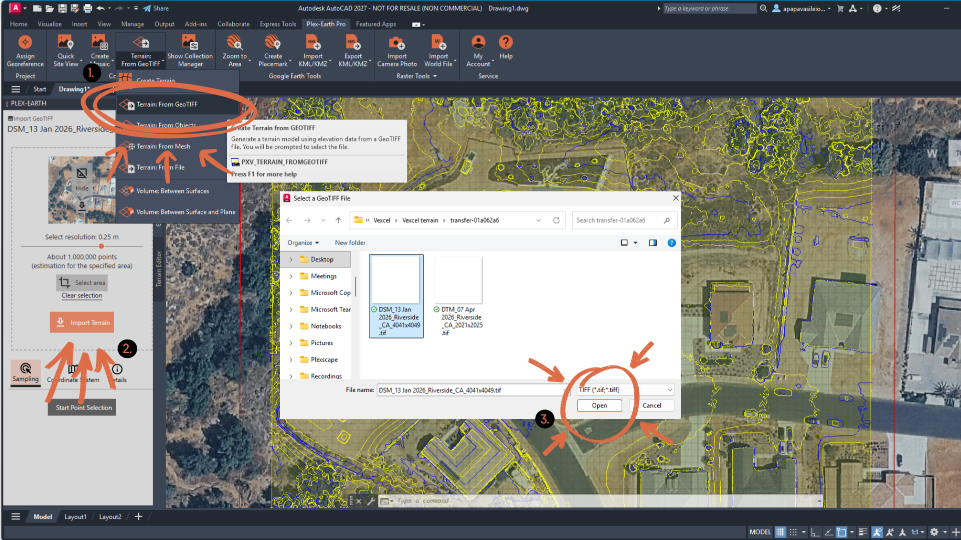
Terrain from GeoTIFF command in Plex-Earth
For coverage information, pricing, and sample data, contact the Plex-Earth Sales team at sales@plexscape.com. To receive a quote, send us a KML or KMZ file outlining the location and boundaries of your project area.
Why choose Vexcel?
Vexcel is the only Premium Provider with native 15 cm aerial imagery covering the entire U.S., urban and rural, on the same program. Native means the imagery is captured at 15 cm, not upscaled to it from lower-resolution satellite data, so you can trust the detail at that resolution for measurement and design, not just for visual reference.
Vexcel is also refreshed frequently, sharp in rural, and even sharper in urban areas, and orthorectified for consistent geometry. For projects that extend across whole states, such as transmission corridors, pipelines, fiber and rail alignments, and large solar farm sites, that combination removes the need to switch between providers as the project moves between dense and rural extents.
Starting January 2027, the story gets stronger in the U.S. as Vexcel's nationwide Wide Area Program doubles from 15 cm to 7.5 cm across the contiguous United States. Meaning that Vexcel imagery already brought into Plex-Earth will keep gaining detail over the life of your subscription.
How does Vexcel compare to the other Premium providers?
Each provider in the Plex-Earth adds another benefit, and Vexcel is one option among several.
Nearmap covers urban areas at extremely high quality and is well-suited to projects concentrated inside metro extents. Hexagon offers wider aerial coverage spanning both urban and rural at a lower price point, though dataset updates are less frequent. Airbus and Vantor (formerly Maxar) are the satellite providers, covering large areas with frequent capture cycles, making them the go-to option when global reach or recency at scale matters more.
The result is a provider library where the choice on any given project comes down to where the site is, how big the project area is, how recent the context needs to be, and how much resolution the design phase requires.
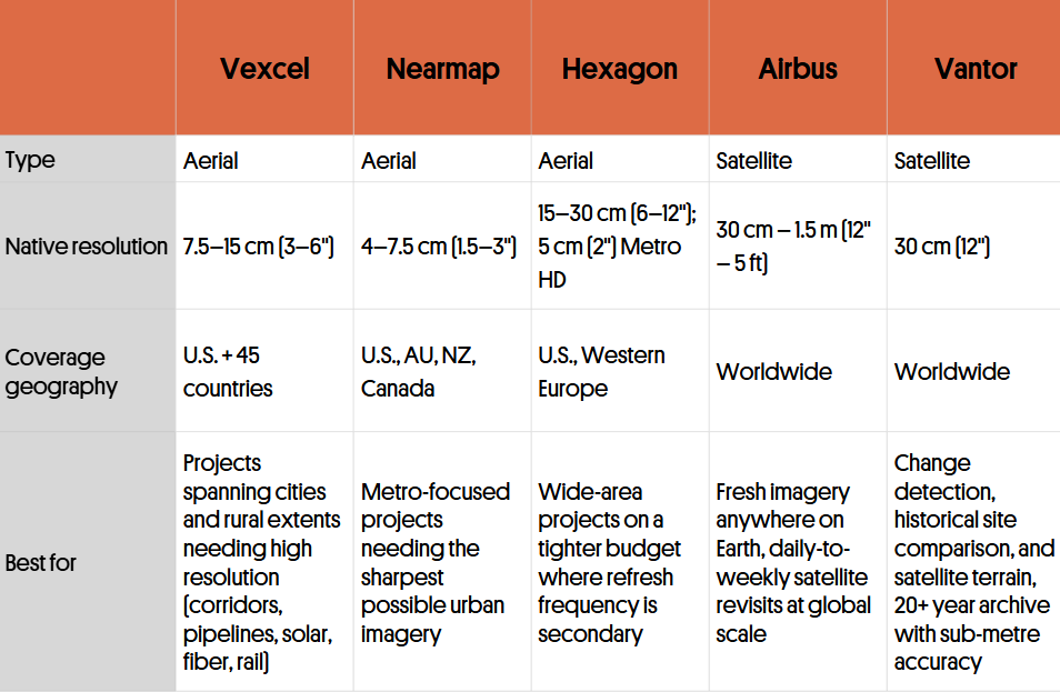
Comparison table of Premium Providers in Plex-Earth
Available now in your subscription
Vexcel imagery and terrain are live in Plex-Earth today. We're looking forward to seeing it on your drawings. For more on the Vexcel Data Program itself, see vexceldata.com.
To learn more on how to access Vexcel, contact us at sales@plexscape.com.
