What the terrain is hiding: Mediterranean coast
That coastline looks flat. Your surface model disagrees.
Looking down from above, the Mediterranean is irresistible.
Turquoise water. Clean shorelines. Orderly ports. Cities are arranged neatly between mountains and the sea.
If you work in civil engineering, planning, or infrastructure design, you’ve likely had this moment: you open imagery. You zoom in. You think, This looks straightforward.
Then reality intervenes, often in the form of a storm, a slope failure, or an unexpected drainage issue, and reminds you that the situation is more complex than it first appeared. That’s because imagery, however recent, only shows the outer shell, but the true risk sits beneath the surface.
The good news? You don’t need to leave your CAD workflow to understand terrain more accurately.
By connecting to country data providers, GeoTIFFs or elevation services for terrain, you can generate a surface model in minutes inside Plex-Earth and see what the site is actually doing vertically.
Let’s look at three Mediterranean examples.
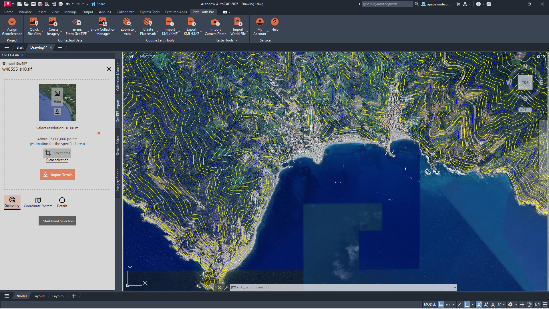
Location: Cinque Terre, Liguria, IT
Provider: Istituto Nazionale di Geofisica e Vulcanologia (INGV)
Image Credit: Plex-Earth-generated surface derived from © INGV (TINITALY/1.1) - CC BY 4.0
Tutorial: Italy: 10 meter DEM - TINITALY/1.1 - INGV – Plex-Earth Support Desk
Italy – Cinque Terre (Liguria)
Cinque Terre also looks dramatic from above.
Colorful villages cling to terraced hillsides.
Rail lines and paths thread between the cliff and the sea.
It looks stable because it has stood for centuries. But that stability has always required intervention.
The Ligurian coast has a long history of landslides and storm damage, intensified when traditional terrace maintenance declined in the 20th century. In October 2011, extreme rainfall triggered destructive floods and debris flows in nearby towns such as Vernazza and Monterosso, causing fatalities and severe infrastructure damage.
These events were not unexpected; they were the natural result of steep terrain meeting intense rainfall.
If you connect to Italian terrain data and generate contours, you will realize:
Slopes frequently exceed 30–40°.
Buildings sit directly below steep catchments.
Drainage paths descend rapidly toward narrow coastal corridors.
Imagery can make the site appear like what you are dealing with is easier than it seems.
But, if you get these terrain-driven decisions wrong at the start, you either massively overbuild (deep foundations, heavy retaining, oversized budget-draining works you didn’t need) or, worse, under-protect the site.
A wrong decision to point all roof/yard water into one long buried pipe instead of an upslope interceptor and an open channel can result in a serious clog, flooded terrace, and ground floor as soon as the first debris-heavy storm water hits.
You can’t control nature, but with smart planning, your design can stand the test of time, too.
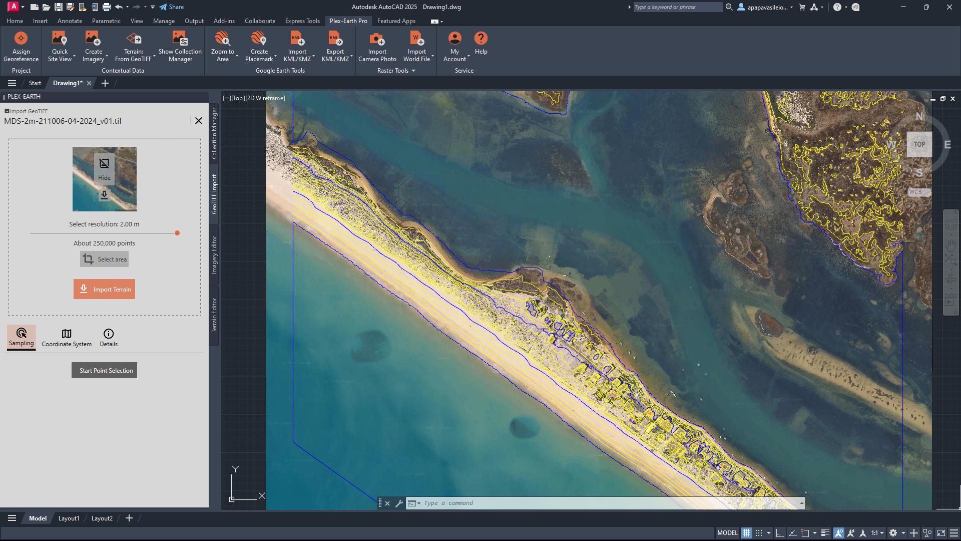
Location: Ria Formosa, Faro, PT
Provider: Direção-Geral do Território (DGT) (the Portuguese Territorial Directorate)
Image credit: Plex-Earth-generated surface derived from © Direção-Geral do Território (DGT) - CC BY 4.0
Tutorial: Portugal: 0.5 and 2 meter DTM and DSM - DGT (the Portuguese Territorial Directorate) – Plex-Earth Support Desk
Portugal – Ria Formosa (Faro)
Ria Formosa looks calm from above.
Barrier islands arc gently offshore.
Lagoons shimmer behind sandy ridges.
Low-rise developments sit along narrow strips of land.
But barrier islands are temporary by nature.
Historical records show repeated storm overwash events and inlet shifts along the Algarve coast. Severe winters in the 1940s and 1960s reshaped sections of the barrier system, and more recent Atlantic storms, including Storm Xynthia (2010) and subsequent winter storm sequences, accelerated erosion and overwash in vulnerable areas.
The landscape is dynamic, even when it looks still.
Import Portuguese terrain data and build a surface, you will notice that:
Large areas sit barely above sea level.
Elevation differences are subtle.
The protective dune ridge is often only a few meters high.
If you run a cross-section from the ocean to the lagoon, you begin to see how narrow the vertical margin really is. What looks like solid, buildable land from above turns out to have surprisingly little height separating sea from inland water.
For marina upgrades, resort planning, or access infrastructure, imagery can suggest open, horizontal opportunity.
But read the terrain wrong, and every spring tide and storm turns the street into a shallow lagoon, the drains burp salty water back toward the house, and the whole place slowly sinks and cracks as that soft lagoon soil squishes under the weight.
Painful, expensive, yet completely avoidable with the right data set.
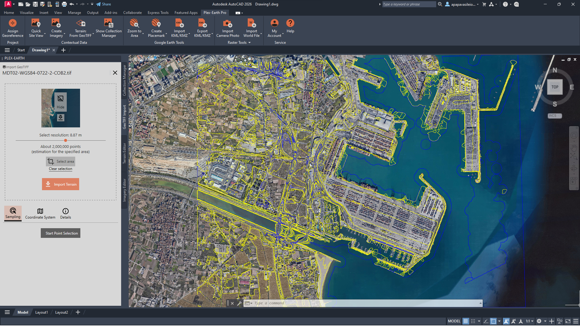
Location: Turia River, Valencia, ES
Provider: National Geographic Institute - Instituto Geográfico Nacional (IGN)
Image Credit: Plex-Earth-generated surface derived from MDT02-cob2 (2015–2021), CC BY 4.0, IGN (scne.es)
Tutorial: Spain: 2 meter DTM - National Geographic Institute – Plex-Earth Support Desk
Spain – Turia River (Valencia)
Valencia looks expansive from above.
Wide beaches.
A vast port.
A flat urban grid extending inland.
It feels engineered, and in many ways, it is. But Valencia has battled floods for centuries.
The most devastating modern event occurred in 1957, when a powerful “gota fría” storm caused the Turia River to overflow, killing at least 81 people. The response was the “Southern Solution” - a massive diversion channel rerouting the river south of the city.
The intervention reduced risk in the historic center. However, the surrounding area remained low and still vulnerable to flooding.
Southern municipalities remained exposed, and a 2008 protection plan was only partially implemented. In 2024, intense rainfall once again caused severe flooding across parts of the Valencia region, reminding planners that low-gradient basins retain their sensitivity.
The pattern persists:
Low gradient.
High-intensity rainfall.
Minimal vertical margin.
If you generate a terrain surface inside CAD, the geometry will explain why:
Large areas sit only slightly above sea level.
Contours are sparse because elevation differences are small.
Engineered platforms contrast with naturally flat basin terrain.
In this setting, 30–50 cm can determine whether water drains or accumulates. Valencia sits over at least two main aquifers (Plana de Valencia Norte/Sur), in a very low-slope plain.
Any basement and underground parking design has to assume buoyancy, permanent dewatering, or at least pressure-rated slabs/walls, and aggressive water chemistry (chlorides, sulfates) that can attack concrete and reinforcement.
If not, you’ll be dealing with floating slabs, leaks, and corrosion.
On top of that, even though the regional seismicity is moderate, the soil profile in the soft downtown/alluvial zones suggests strong amplification effects. In other words, this soil shakes more and at different periods than rock sites.
Making the right, data-informed decision early can mean preventing a moderate earthquake from doing disproportionate damage to your structure.
The Mediterranean Pattern
To wrap this up:
Italy hides instability behind beauty.
Portugal hides fragility behind calm water.
Spain hides vulnerability inside subtle elevation.
Different geographies. Different historical lessons. Same conclusion.
Imagery shows you what looks possible. Elevation shows you what is probable.
Each coastline appears inviting and manageable when viewed through imagery alone.
Connecting to the right country providers and importing reliable terrain data into CAD helps you replace assumptions with real insight, often in just a few minutes.
The question is not whether the data exists. It is whether we use the right surface data early enough to see what the coastline is really telling us.
Curious if we have the right data provider for you?
Browse our curated list of providers here.