
An overview of Vexcel, Nearmap, Hexagon, Airbus and Vantor imagery in Plex-Earth: resolution, coverage and use cases.
Many engineers have been in a situation where they need to get accurate site context from a satellite or aerial image, but when they zoom in, they notice that it’s three years old. This results in a building that’s been demolished still appearing to be standing in the image, or a road that’s been widened still showing the old alignment.
Basemap imagery is fine for having a quick overview of your project area in the first project phases, and Plex-Earth comes with plenty of options, like Google Maps, Azure Maps, and OpenStreetMap. But it often isn’t enough once analysis, planning, and design get involved, so that’s where premium providers come in.
The main benefits of premium providers include:
Higher resolution, which helps you identify and measure details such as curbs, edges, and rooftops.
Better accuracy from orthorectified imagery that reduces distortions from the image capture process for more reliable results.
Fresher imagery, sometimes just days old from satellite providers, giving you a more up-to-date view of site conditions.
Historical archives, which enable you to compare a site today with how it looked years ago, supporting change analysis, brownfield reviews, coastal studies, or flood modeling.
Plex-Earth integrates with five of them: Vexcel, Nearmap, Hexagon, Airbus, and Vantor. Each provider has its own strengths, making it a good fit for different project types and requirements. With this range of options, we’re confident you’ll find the right imagery for your project.
Vexcel
Imagery
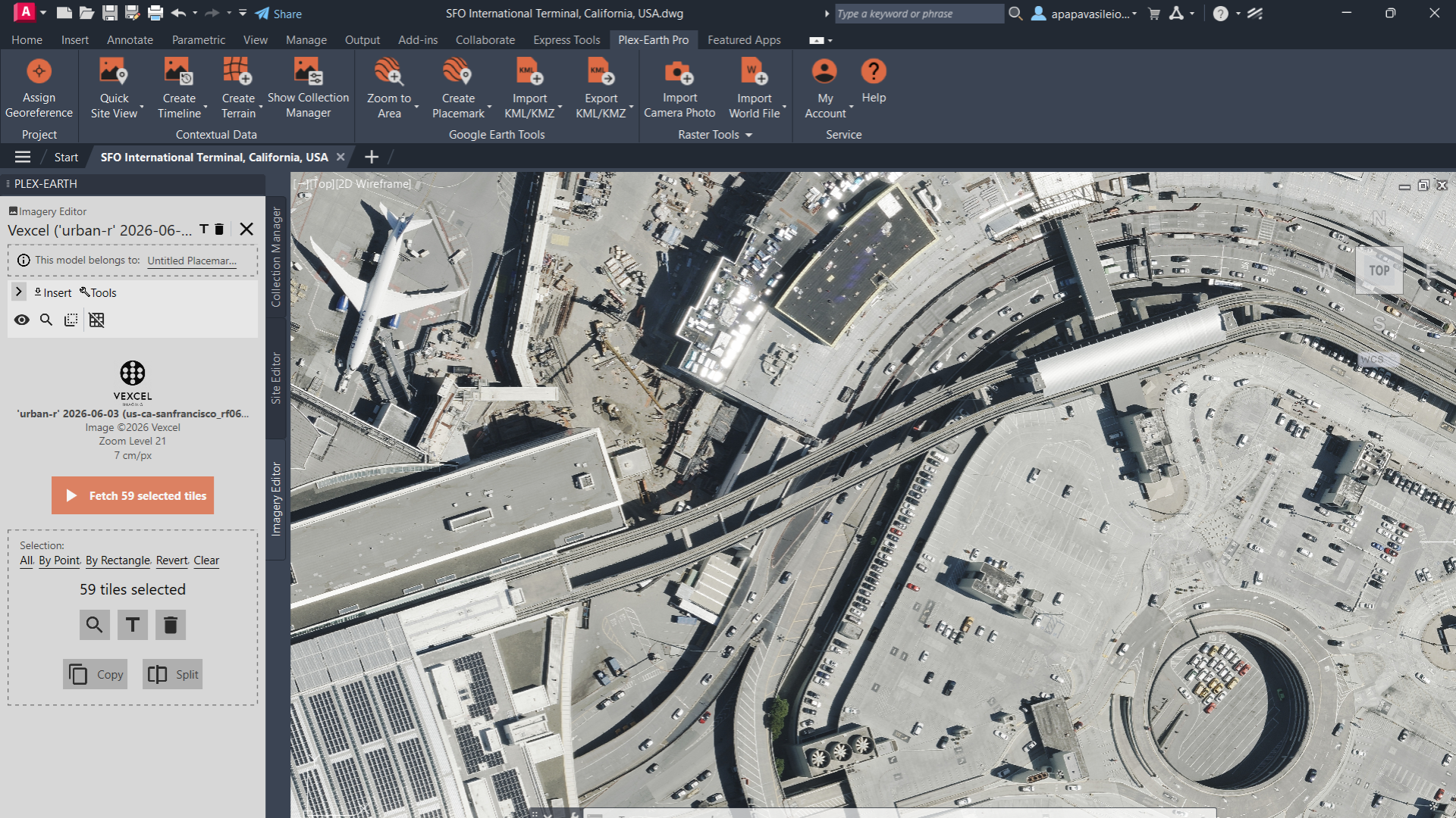
Vexcel 7.5 cm (3 in) imagery of San Francisco International Airport in AutoCAD with Plex-Earth.
Type: Aerial
Capture: Vexcel's own fleet of aircraft, using proprietary UltraCam large-format sensors
Coverage: Full US (urban + rural) plus active collection in 45+ countries
Resolution: 7.5 cm (3 in) in urban areas, 15 cm (6 in) across rural and wide-area coverage
Refresh: Up to 3× per year in major US metros; 5.17 million km² (2 million sq mi) refreshed across the US in 2026
Vexcel stands out for the level of detail it delivers well beyond city centres. Its aerial programs capture entire states at 15 cm (6 in), with 7.5 cm (3 in) in urban areas. Rural sites, which many other programs skip or cover at lower resolution, get the same high level of detail. That makes Vexcel a strong choice for wide-area projects such as corridors, pipelines, solar farms, fiber networks and rail, where fine features matter along the whole route.
Historical datasets are also available for many locations, some dating back to 2012, so project teams can compare current site conditions with previous years. In January 2027, Vexcel begins the first nationwide US aerial imagery program at 7.5 cm (3 in), bringing urban-grade detail to the entire contiguous United States.
Best for: Wide-area US projects that need the highest detail across both urban and rural areas (corridors, pipelines, solar, fiber, rail).
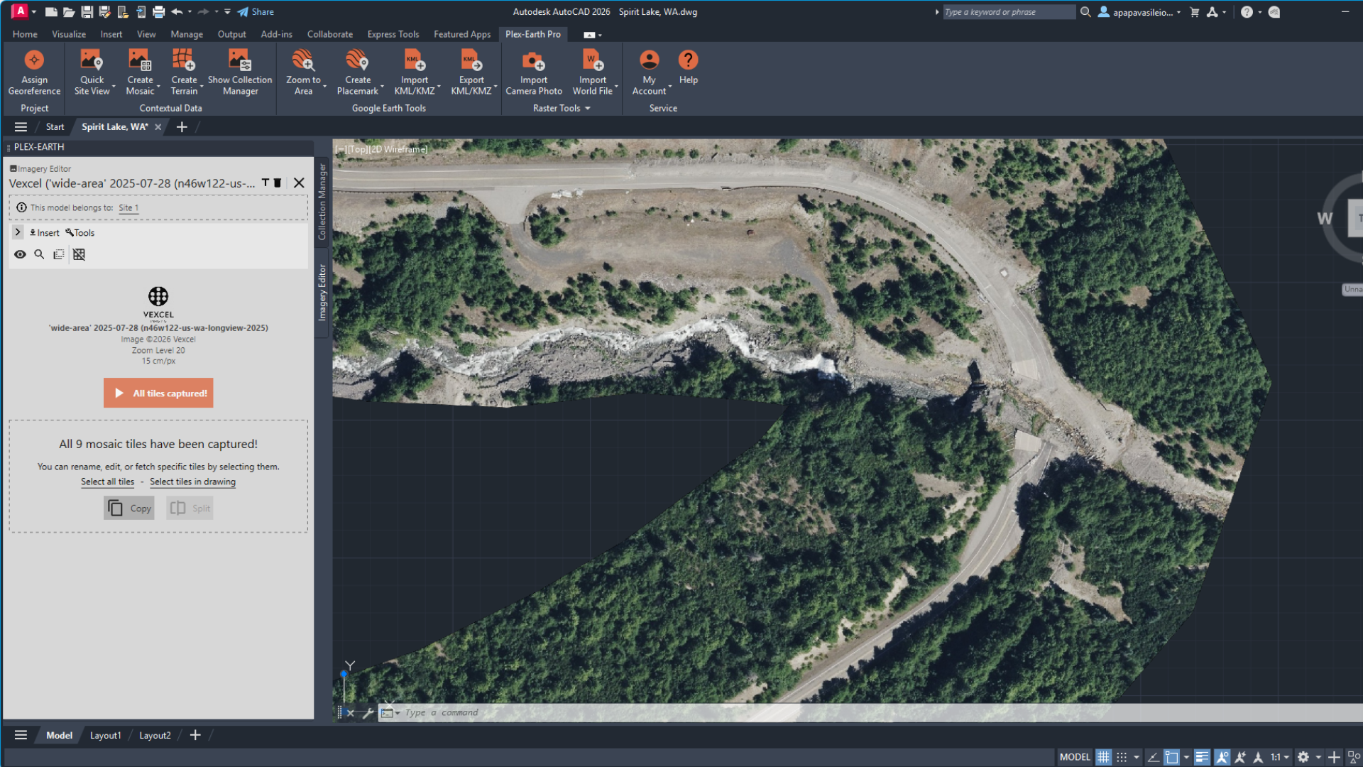
Vexcel 15 cm (6 in) wide-area imagery imported into AutoCAD with Plex-Earth, showing a road and river crossing near Spirit Lake, Washington.
Terrain (Elevate Products)*
Resolution: DSMs at 7.5 cm (3 in), DTMs at 15–20 cm (6–8 in)
Coverage: Full US, aligned with Vexcel's aerial imagery program
Vexcel’s elevation models come from the same aerial capture as its imagery. Its DSM and DTM are aligned pixel by pixel with the ortho and multispectral layers, meaning each elevation value corresponds to the same location represented in the imagery. This provides a consistent spatial basis for area, height, and volume calculations, reducing the need for additional dataset alignment before analysis. Useful for property analysis, telecom line-of-sight studies, and site-scale volume takeoffs.
Nearmap
Imagery
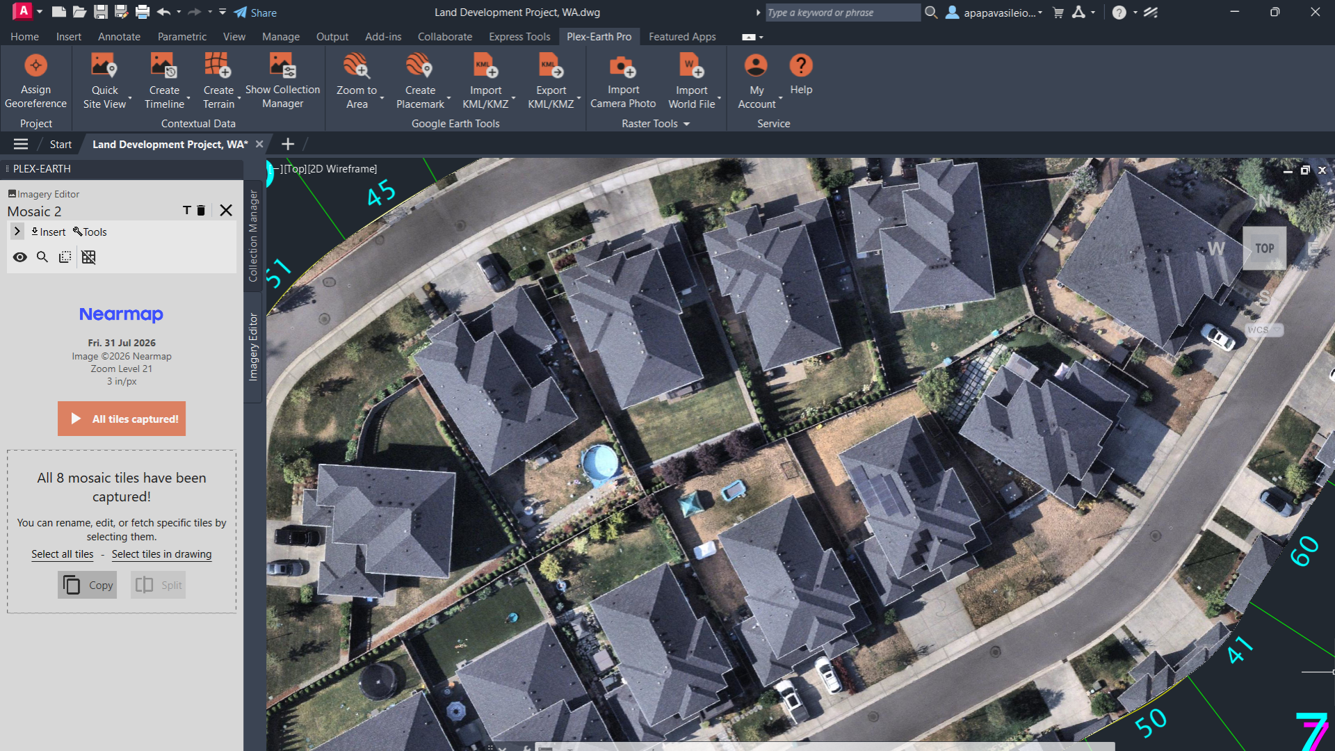
Nearmap 7.5 cm (3 in) imagery imported into AutoCAD with Plex-Earth for a residential land development project in Washington.
Type: Aerial
Capture: Nearmap's own fleet of aircraft, using its proprietary HyperCamera3 system
Coverage: Urban and suburban areas of the US, Australia, New Zealand, and Canada
Resolution: 4–7.5 cm (1.5–3 in) per pixel
Refresh: Up to 3× per year in US metros, up to 6× per year in Australian city centres
Nearmap’s strength lies in the detail and geometric accuracy of its imagery. Its extremely high-resolution captures support close inspection of features such as roof tiles, curb edges, and stormwater grates, helping project teams assess site conditions and make early design decisions before an on-site visit. Frequent aerial surveys over major metropolitan areas also help keep the imagery up to date, providing a more recent view of the site as planning and design progress.
Best for: Urban and suburban projects in the US, Australia, New Zealand, and Canada where high-resolution ground context matters for early-stage design ((urban development, civil site design, transportation, streetscapes, utilities, local fiber networks).
Terrain (Nearmap 3D program)*
Resolution: DSM at 15 cm (6 in); DTM exports at 30, 60, or 90 cm (12, 24, or 36 in)
Coverage: Urban and suburban areas of the US, Australia, New Zealand, and Canada — aligned with Nearmap's aerial imagery program
Nearmap’s high-resolution elevation products complement its aerial imagery, providing detailed surface and terrain data for urban projects. Its DSM supports analysis of building forms and above-ground features, while its DTM helps teams assess ground elevations and local variations in slope. Frequent capture programs, up to three times a year in US metropolitan areas and six times a year in Australian urban areas—provide a regularly updated record of site conditions. Where elevation datasets are available for multiple dates, teams can compare changes over time to support construction monitoring, earthworks assessment, and reviews of changes following storms.
Hexagon
Imagery
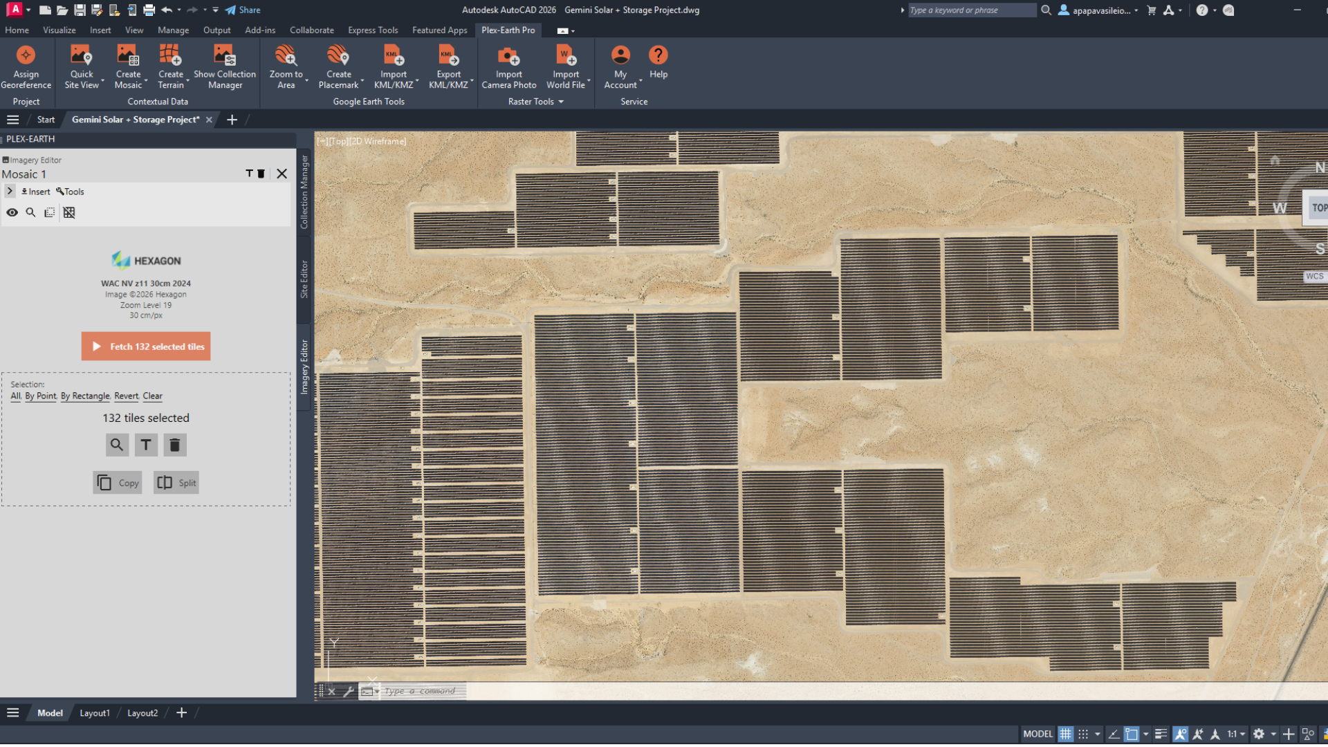
Hexagon 30 cm (12 in) wide-area imagery in AutoCAD with Plex-Earth, covering the Gemini Solar + Storage project in Nevada
Type: Aerial
Capture: Partner-flown aircraft using Leica Geosystems airborne sensors
Coverage: Contiguous US, large parts of Western Europe, selected Canadian cities
Resolution: 15 cm (6 in) in urban areas, 30 cm (1 ft) across wider rural coverage
Refresh: Entire US states and European countries captured in a single flying season
Hexagon’s strength is consistency across the whole project extent. It captures entire US states and European countries in a single flying season, then orthorectifies and colour-balances the result into one seamless dataset. The capture season, colours and lighting stay the same from one end of your project to the other.
Combining imagery from different datasets can introduce colour shifts, visible seams and changes in lighting or resolution. On a project that stretches across counties, states or national borders, those differences make the imagery harder to read and to present. Hexagon’s unified datasets avoid them, so the whole area reads as one image with one published accuracy figure. Four-band capture (RGB plus near-infrared) also helps separate vegetation from hard surfaces along a route.
Best for: Wide-area projects that need one seamless dataset across the full area of interest (corridors, pipelines, solar, fiber, rail).
Airbus
Imagery
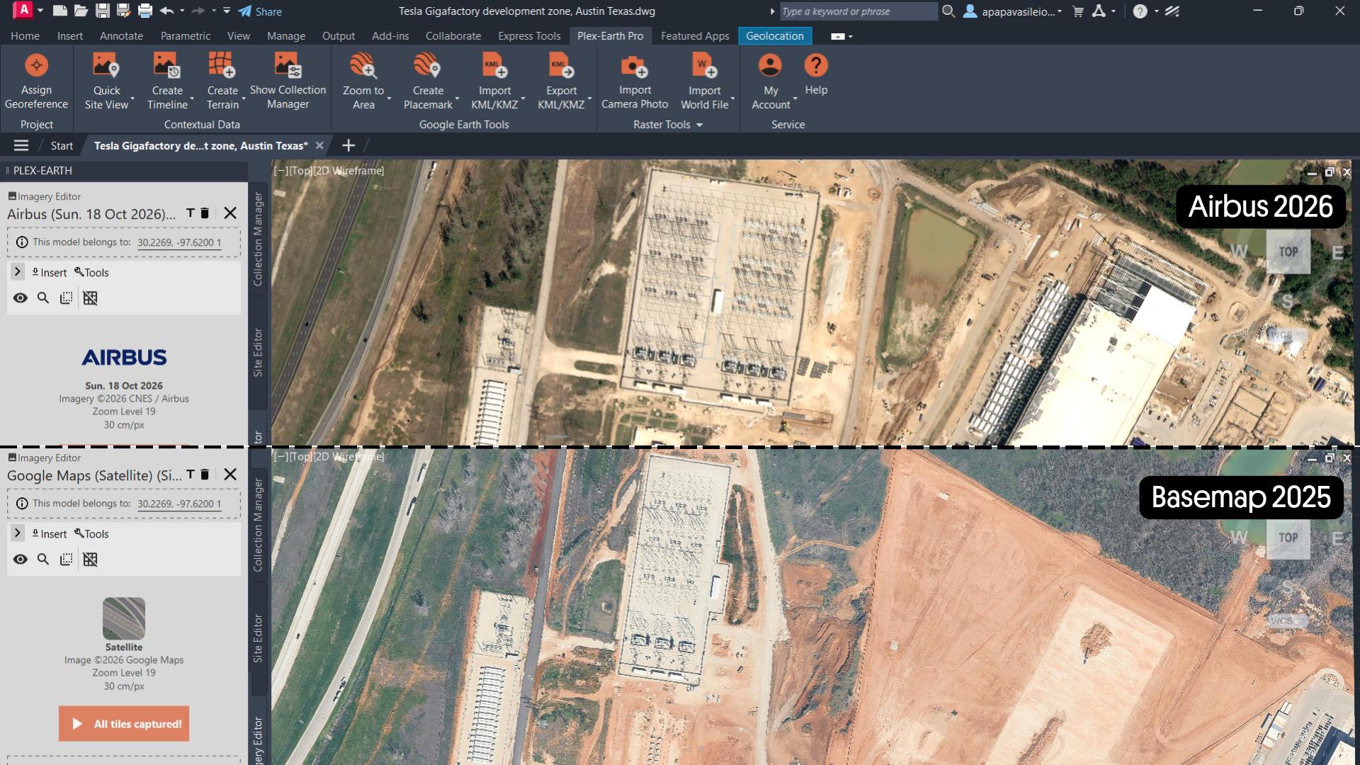
Airbus 2026 satellite imagery (top) compared with the 2025 basemap (bottom) at Tesla's Gigafactory site in Austin, Texas, showing recent construction.
Type: Satellite (optical)
Capture: Multi-satellite constellation delivered through the OneAtlas platform
Coverage: Global — accessible across most of the world, including areas outside active aerial programs
Resolution: Pléiades Neo at 30 cm (~12 in), Pléiades at 50 cm (~20 in), SPOT at 1.5 m (~5 ft)
Airbus stands out for its global coverage and the availability of recent satellite imagery. Frequent satellite revisits support regular monitoring, while its archive combines years of historical imagery with captures that, in some locations, may be just days old. This makes Airbus a practical option for tracking construction progress, observing seasonal changes in site conditions, and assessing damage after natural disasters. Its range of imagery resolutions also allows teams to match the level of detail to their project’s needs, with Pléiades Neo suited to detailed site analysis and SPOT to broader regional coverage.
Best for: International projects that need the most current view of the site, from detailed site checks to regional overviews (construction monitoring, disaster damage assessment, international infrastructure, mining and quarries, regional planning, early-stage feasibility).
Vantor (formerly Maxar)
Imagery
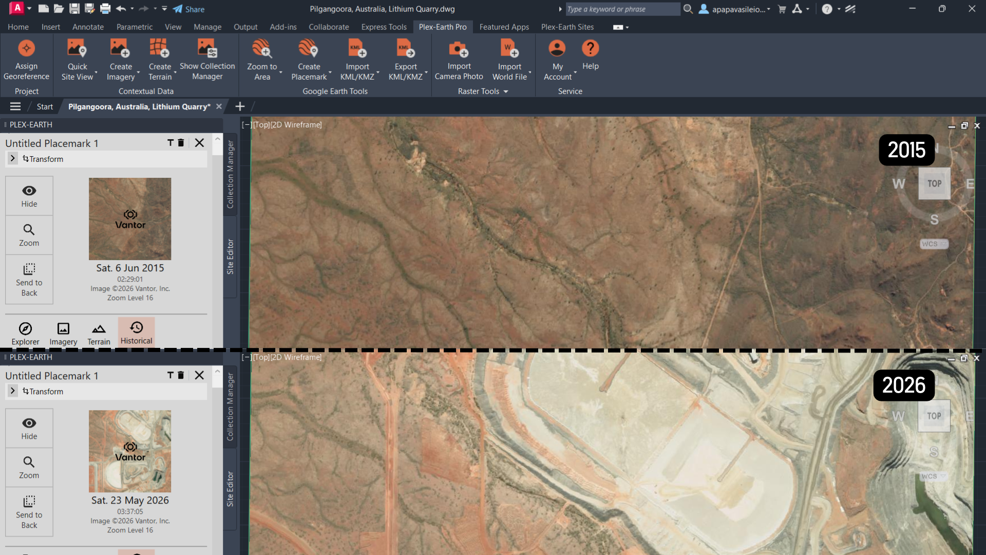
Vantor satellite imagery from 2015 and 2026 in AutoCAD with Plex-Earth, showing the Pilgangoora lithium mine in Australia before and after development.
Type: Satellite
Capture: WorldView constellation — ten spacecraft, including six WorldView Legion satellites launched between 2024 and 2025
Coverage: Global — accessible across most of the world
Resolution: 30 cm (~12 in) class across most of the fleet
Refresh: Up to 15 revisits per day at mid-latitudes on WorldView Legion
Vantor's edge is the sheer variety of datasets available. Alongside global coverage similar to Airbus, Vantor maintains a large, deep library of satellite imagery across time, resolution, and site type. Whether the project needs the sharpest current capture, a mid-resolution overview, or a historical view of how a site looked years back, there's usually a dataset in the archive that fits. This makes Vantor well suited to brownfield assessments, monitoring changes to infrastructure over time, and land-use history studies.
Best for: Global coverage for projects that need the widest choice of imagery for a site (historical & up-to-date), across many dates and resolutions, plus satellite terrain where no survey exists (brownfield assessments, environmental studies, coastal change, long-term asset monitoring, remote energy sites, terrain for remote areas). Includes print rights for project deliverables.
Terrain (Vivid Terrain Program)*
Resolution: 50 cm (~20 in) post spacing
Vertical accuracy: under 3 m (~10 ft) LE90
Coverage: Global — built from Vantor's satellite archive
Vivid Terrain uses automated 3D modelling to reconstruct surface and terrain models from satellite imagery. With coverage exceeding 100 million km², it offers 50 cm resolution and a stated absolute accuracy of 3 m without ground control points. This combination makes it a practical option for remote locations and projects where field access is limited or surveys are difficult to arrange. Vivid Terrain also comes with companion layers: point cloud, building vectors, and land-use classification, for teams that need more than just elevation.
*Delivery of terrain products: GeoTIFF, custom order only — contact us at sales@plexscape.com for coverage and delivery.
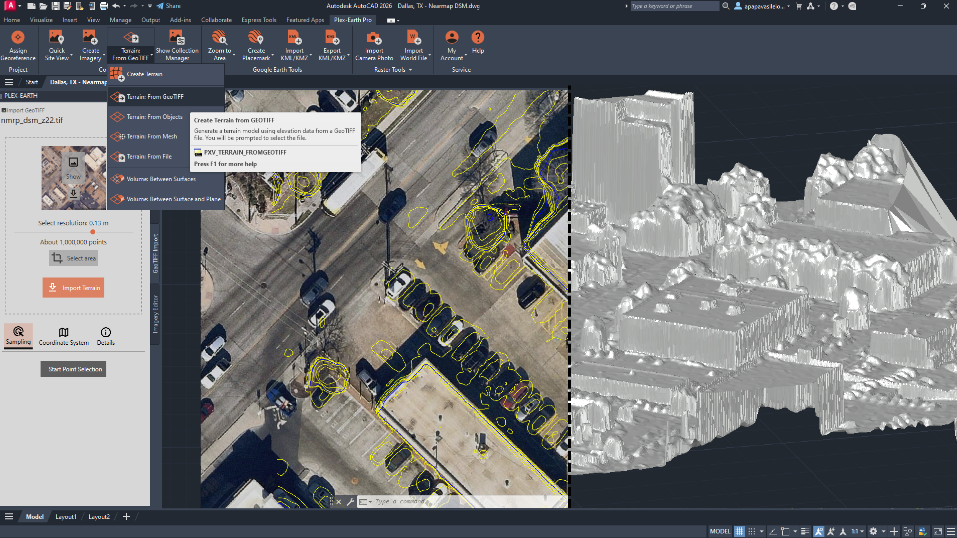
A Nearmap DSM imported into AutoCAD with Plex-Earth’s Terrain from GeoTIFF tool, shown as contours over the imagery (left) and as a 3D surface model (right) in Dallas, Texas.
How to choose what's right for your project
Every project is different, but the decision usually comes down to four questions:
1. Where is the project?
Geographic coverage is the first factor to consider, as aerial imagery providers operate within defined regions. Nearmap focuses on urban and suburban areas in the US, Australia, New Zealand, and Canada; Vexcel’s program spans 45+ countries and territories, with imagery available in all 50 US states; and Hexagon offers coverage in the US, Europe, and parts of Canada. For project sites outside these aerial coverage areas, satellite providers such as Airbus and Vantor offer a practical alternative through their global imagery collections, particularly for remote locations and infrastructure projects in regions with limited aerial coverage.
2. How much detail do you need?
Detailed tasks such as measuring rooflines, identifying curbs and small assets, or planning at street level benefit from high-resolution aerial imagery. Nearmap delivers the finest detail in urban and suburban areas at 4–7.5 cm (1.5–3 in), while Vexcel offers high-quality imagery across entire states, at 7.5 cm (3 in) in cities and 15 cm (6 in) in rural areas. For wide-area projects such as regional corridors, rural highways or solar farms, consistency across the full extent often matters as much as resolution. Hexagon captures whole states as a single, seamless dataset, so the imagery stays uniform from one end of the project to the other. Satellite imagery works for most design contexts, but doesn’t match aerial for fine-grained measurement.
3. Does the imagery need to be recent?
Aerial providers refresh their coverage on planned schedules, up to 3 or 6 times a year in major metros for Nearmap and Vexcel. That's often enough for design work, but when a project needs to track something that's changing week to week, like active construction, ground movement, damage from a natural disaster, satellite refresh rates are higher, and fresh captures are sometimes just days old. Airbus and Vantor both hold recent imagery over most of the world's active project sites.
4. Do you need historical data?
Historical archives allow you to compare a site today with how it looked years ago, supporting change analysis, brownfield assessments, and coastal studies. Vexcel's archive goes back to 2012 across most of the US. Airbus and Vantor maintain extensive global satellite archives, regularly expanded through new captures. For many locations, this provides imagery from multiple dates, helping teams track recent changes or compare current site conditions with how the area looked 15 years ago or earlier.
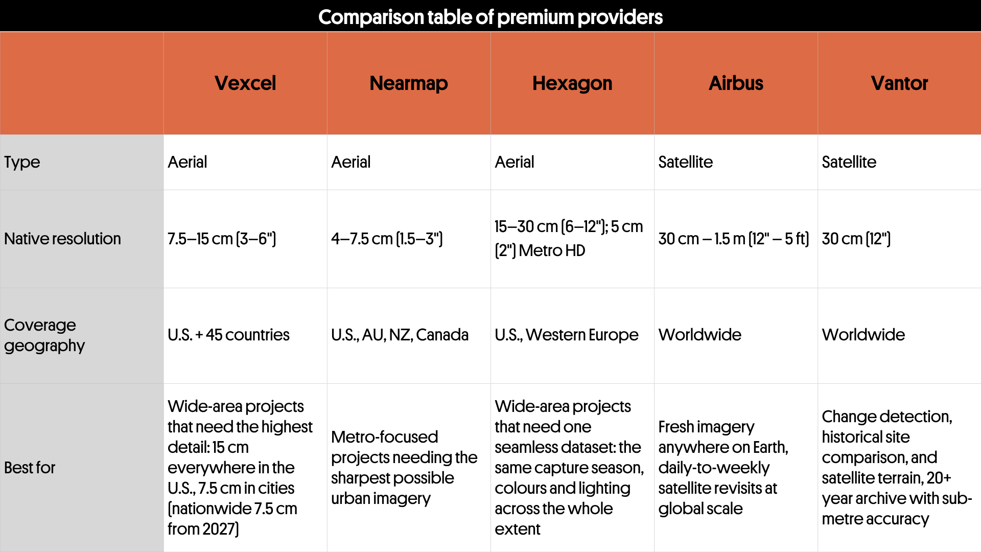
Premium imagery providers in Plex-Earth at a glance: type, resolution, coverage, usage rights and best use cases.
Not sure where to start?
Every project has its own mix of location, detail, and timing. If you're still not sure what imagery or terrain data would fit best, talk to our team; we'll help you match the provider to the project.
