How to import objects from Google Earth into AutoCAD with a simple copy - paste
What is the easiest way to import objects and imagery from Google Earth into AutoCAD in 2026?
Combining your CAD with Google Earth is a great way to improve your productivity and take advantage of both worlds:
You can share geographically-based information with colleagues, partners and other shareholders very easily. For example, you may directly digitize an area of interest in Google Earth and then pass that information to AutoCAD.
There’s a ton of data available out there, from companies, organizations and universities, which could be very important for your design. For example, geological maps for your construction, mining, environmental or road design.
Import Google Maps imagery for faster preliminary ideas and concepts
In the video below you can see how easy it is to import elements into your designs, simply by opening them in Google Earth and then copying objects into AutoCAD.
With Plex-Earth’s newest version this has been even more simple, because now you can import objects (placemarks, paths, polygons), or even whole groups of objects (Folders) and KML documents, along with their data, into your CAD of preference (AutoCAD and BricsCAD), with a simple copy & paste operation.
If you don’t have Plex-Earth yet, you can start a free trial here, otherwise, make sure you have the latest version installed.
Here are the steps:
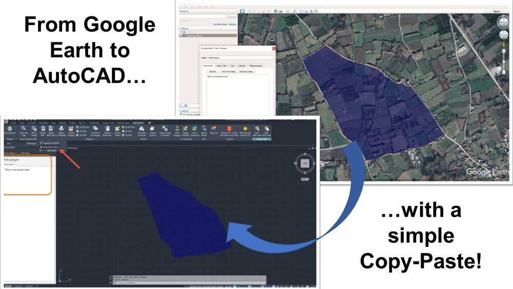
Step 1: Open Google Earth and create a placemark, path or polygon, or simply load an existing KML/KMZ file. Here we are creating a polygon that covers our project area, and we also specify the name and the description of our object in Google Earth.
Step 2: Right-click on the polygon, and select “Copy”
Step 3: Open your AutoCAD drawing, right-click and select “Clipboard” → Paste, or simply press Ctrl-V.
The polygon is now imported and correctly aligned into AutoCAD.
Plex-Earth boosts your productivity and streamlines your design process, in any type of civil engineering, environmental or energy project, by enabling you to:
Insert high-resolution satellite imagery from Google Maps and other map services (WMS, TileServers etc)
Import detailed terrain meshes, contours and perform terrain analysis with elevation data from Google Earth, your own surveys or other sources
Import your 2D and 3D CAD drawings into Google Earth
Furthermore, with our new Timeviews™ feature, you gain access to the best and most up-to-date satellite imagery from Airbus and Maxar Technologies (DigitalGlobe).
Haven’t you tried it yet? Download and start your free trial now!