
Let’s make your designs irresistible
Impress and engage clients and stakeholders, winning their hearts, their appreciation – and the contract – by taking advantage of Google Earth’s compelling and interactive experience!
Now you can export whole drawings into Google Earth, allowing everyone to easily tour and understand your design or proposals. It even helps you with such creative design touches as ensuring the best angles or views that people will see – and photograph – from inside or outside your construction!
Such elegance creates truly valuable selling points, for both the client’s project when completed, and for you as the superior designer.
Now you can boost your proposal with Virtual tours!
Once your project is in Google Earth you have some serious presentation power in your hands, because as well as sharing static images you can now produce and share stunning virtual tours!
Creating a tour is easy, moving the camera along a specified route and showing all the important details of your design. Plex-Earth combined with Movie Maker (available in Google Earth Pro, which is now FREE!) enables you to produce high definition video which you can upload to YouTube or embed in your site. Can you imagine the possibilities?
Showcase drawings exactly as you see them in AutoCAD…
Plex-Earth uniquely supports all AutoCAD objects and preserves their look and feel when in Google Earth, such as linework, text, hatch, blocks, external references and so on.
…And maintain drawing’s structure for layers and blocks
You can dynamically select which elements are visible within Google Earth, while navigating in it. Just like in AutoCAD, once exported in Google Earth, layers can be switched on or off, so you can highlight and explain your design aspects to your customers. You can also…
Keeps information attached to drawing objects
Your drawings may contain valuable data attached to specific objects, which is necessary for someone to understand the details of your design. For example a pipe’s diameter, cable types or the area of a land parcel. This data can be in the form of object attributes or, if you use Civil 3D or Map 3D, GIS object data. In any case, Plex-Earth preserves and includes this information along with the related objects, when exported into Google Earth.
We're here for you!
We proudly offer you more than just self-service software, in fact we believe our commitment to ensuring you can use ALL the power and capabilities is one of Plex-Earth’s greatest features! Don’t hesitate to talk with us about your ongoing projects, because we will be delighted to help you – we love this stuff!
Because seeing is believing!

A whole drawing, as seen in Google Earth. Note that the layers and blocks’ structure is maintained.
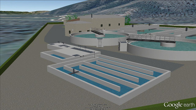
Detail view of a wastewater treatment plant in Google Earth.
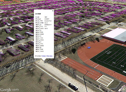
A pop-up showing, inside Google Earth, the information (GIS) attached to an object exported from AutoCAD.

A generic view of a solar park in Google Earth